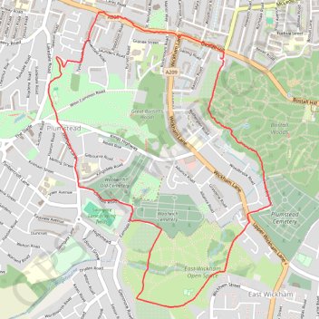
Plumstead Parks Loop
Loop hike in Plumstead via Winns Common, East Wickham Open Space and Bostall Woods. #Hiking #Loop #City #Park #Nature #Forest
- Distance: 3.5 mi
- Elevation gain: 256 ft
- Maximum elevation: 184 ft
- Elevation loss: 246 ft
- Minimum elevation: 43 ft
- Moving time: 1 h 11 m
- Moving speed: 3.0 mph
- Maximum speed: 5.1 mph
- Total time: 1 h 11 m
- Global speed: 3.0 mph
Interactive trail map
Trail profile
- Distance: 3.5 mi
- Elevation gain: 256 ft
- Maximum elevation: 184 ft
- Elevation loss: 246 ft
- Minimum elevation: 43 ft
- Moving time: 1 h 11 m
- Moving speed: 3.0 mph
- Maximum speed: 5.1 mph
- Total time: 1 h 11 m
- Global speed: 3.0 mph
About this trail
Name: Plumstead Parks Loop trail, distance, elevation, map, profile, GPS track
Coordinates: 51.47070 0.09110 51.48676 0.11052
Other hiking, mountain biking, running and outdoor activity trails
Click on a trail to view its statistics, map and profile.
Oxleas Woods
United Kingdom > England > London
Morning Walk
Distance: 6.7 mi • Elevation gain: 489 ft • Maximum elevation: 420 ft
Bostall Woods to Danson Park Loop Run
United Kingdom > England > London
Distance: 7.5 mi • Elevation gain: 390 ft • Maximum elevation: 220 ft
Erith Marshes
United Kingdom > England > London
Morning Walk
Distance: 5.6 mi • Elevation gain: 348 ft • Maximum elevation: 240 ft
Lesnes Abbey Woods
United Kingdom > England > London
Morning Walk
Distance: 3.8 mi • Elevation gain: 338 ft • Maximum elevation: 223 ft
Lesnes Abbey Park
United Kingdom > England > London
Morning Walk
Distance: 4.2 mi • Elevation gain: 289 ft • Maximum elevation: 240 ft
Danson Park
United Kingdom > England > London
Morning Walk
Distance: 5.3 mi • Elevation gain: 295 ft • Maximum elevation: 217 ft
Woolwich Common
United Kingdom > England > London
Morning Walk
Distance: 7.1 mi • Elevation gain: 440 ft • Maximum elevation: 217 ft
Shrewsbury Park
United Kingdom > England > London
Morning Walk
Distance: 4.6 mi • Elevation gain: 397 ft • Maximum elevation: 305 ft
Woolwich Common
United Kingdom > England > London
Morning Walk
Distance: 9.0 mi • Elevation gain: 663 ft • Maximum elevation: 384 ft
Crossway Park
United Kingdom > England > London
Morning Run
Distance: 6.0 mi • Elevation gain: 125 ft • Maximum elevation: 72 ft
Crossway Park
United Kingdom > England > London
Morning Run
Distance: 5.9 mi • Elevation gain: 121 ft • Maximum elevation: 75 ft
Shooters Hill
United Kingdom > England > London
Morning Walk
Distance: 5.7 mi • Elevation gain: 469 ft • Maximum elevation: 417 ft
Thamesmead
United Kingdom > England > London
Morning Run
Distance: 4.2 mi • Elevation gain: 79 ft • Maximum elevation: 69 ft
Thamesmead
United Kingdom > England > London
Lunch Walk
Distance: 5.9 mi • Elevation gain: 282 ft • Maximum elevation: 220 ft