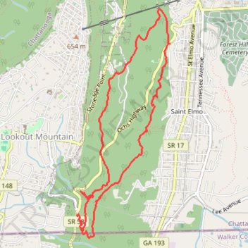
Loop hike to Glen Falls
- Distance: 5.2 mi
- Elevation gain: 1,365 ft
- Maximum elevation: 1,512 ft
- Elevation loss: 1,368 ft
- Minimum elevation: 853 ft
- Moving time: 2 h 11 m
- Moving speed: 2.4 mph
- Maximum speed: 5.0 mph
- Total time: 2 h 26 m
- Global speed: 2.1 mph
Interactive trail map
Trail profile
- Distance: 5.2 mi
- Elevation gain: 1,365 ft
- Maximum elevation: 1,512 ft
- Elevation loss: 1,368 ft
- Minimum elevation: 853 ft
- Moving time: 2 h 11 m
- Moving speed: 2.4 mph
- Maximum speed: 5.0 mph
- Total time: 2 h 26 m
- Global speed: 2.1 mph
About this trail
Name: Loop hike to Glen Falls trail, distance, elevation, map, profile, GPS track
Coordinates: 34.98313 -85.34405 35.00807 -85.33166
Topography: Chattanooga topographic map, elevation, terrain
Other hiking, mountain biking, running and outdoor activity trails
Click on a trail to view its statistics, map and profile.
Cloudland to Ross Landing
United States > Georgia > Dade County
River to Clouds Route
Distance: 34.4 mi • Elevation gain: 3,635 ft • Maximum elevation: 2,057 ft