Make a donation
Gear up for your next adventure:
As an Amazon Associate, this site earns from qualifying purchases at no extra cost to you.
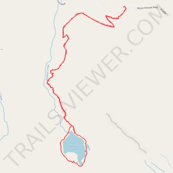
Heather Lake Trail in Mount Baker Snoqualmie National Forest
Heather Lake Trail in the Mount Baker-Snoqualmie National Forest offers hikers a journey through diverse landscapes, beginning in dense second-growth forest adorned with remnants of ancient cedar stumps, relics from past logging activities. As the trail ascends, it transitions into lush old-growth woodland, where towering western redcedars and mountain hemlocks create a serene canopy, accompanied by the soothing sounds of cascading creeks. Upon reaching Heather Lake, nestled beneath the rugged cliffs of Mount Pilchuck, visitors are rewarded with tranquil waters reflecting the surrounding peaks and, in summer months, vibrant wildflowers that fringe the lakeshore. #Hiking #Loop #Lake #Forest #Mountain #Nature
- Distance: 4.9 mi
- Elevation gain: 1,319 ft
- Maximum elevation: 2,513 ft
- Elevation loss: 1,319 ft
- Minimum elevation: 1,391 ft
- Moving time: 2 h 3 m
- Moving speed: 2.4 mph
- Maximum speed: 8.0 mph
- Total time: 2 h 27 m
- Global speed: 2.0 mph
Interactive trail map
Make a donation
Gear up for your next adventure:
As an Amazon Associate, this site earns from qualifying purchases at no extra cost to you.
Trail profile
- Distance: 4.9 mi
- Elevation gain: 1,319 ft
- Maximum elevation: 2,513 ft
- Elevation loss: 1,319 ft
- Minimum elevation: 1,391 ft
- Moving time: 2 h 3 m
- Moving speed: 2.4 mph
- Maximum speed: 8.0 mph
- Total time: 2 h 27 m
- Global speed: 2.0 mph
Make a donation
Gear up for your next adventure:
As an Amazon Associate, this site earns from qualifying purchases at no extra cost to you.
About this trail
Name: Heather Lake Trail in Mount Baker Snoqualmie National Forest trail, distance, elevation, map, profile, GPS track
End: Mount Pilchuck Road, Snohomish County, Washington, United States (48.08337 -121.77410)
Coordinates: 48.06590 -121.78665 48.08343 -121.77369
Topography: Snohomish County topographic map, elevation, terrain
Make a donation
Gear up for your next adventure:
As an Amazon Associate, this site earns from qualifying purchases at no extra cost to you.
Other hiking, mountain biking, running and outdoor activity trails
Click on a trail to view its statistics, map and profile.
Northern part of the Pacific Crest Trail (PCT)
United States > Oregon > Klamath County
Hike on the Pacific Crest National Scenic Trail from Crater Lake to Canada Border through Oregon and Washington along the Sierra Nevada and Cascade mountain ranges. #Hiking #Mountain #SierraNevada #Cascade #Nature #Forest #Park #PCT
Distance: 744.6 mi • Elevation gain: 145,367 ft • Maximum elevation: 7,569 ft
Heather Lake Trail
United States > Washington > Snohomish County > Verlot
Distance: 5.3 mi • Elevation gain: 1,427 ft • Maximum elevation: 2,513 ft
Make a donation
Gear up for your next adventure:
As an Amazon Associate, this site earns from qualifying purchases at no extra cost to you.