Make a donation
Gear up for your next adventure:
As an Amazon Associate, this site earns from qualifying purchases at no extra cost to you.
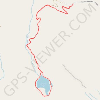
Heather Lake Loop
Interactive trail map
Make a donation
Gear up for your next adventure:
As an Amazon Associate, this site earns from qualifying purchases at no extra cost to you.
Trail profile
- Distance: 4.4 mi
- Elevation gain: 1,263 ft
- Maximum elevation: 2,510 ft
- Elevation loss: 1,263 ft
- Minimum elevation: 1,401 ft
Make a donation
Gear up for your next adventure:
As an Amazon Associate, this site earns from qualifying purchases at no extra cost to you.
About this trail
Name: Heather Lake Loop trail, distance, elevation, map, profile, GPS track
Coordinates: 48.06589 -121.78676 48.08292 -121.77391
Topography: Snohomish County topographic map, elevation, terrain
Make a donation
Gear up for your next adventure:
As an Amazon Associate, this site earns from qualifying purchases at no extra cost to you.
Other hiking, mountain biking, running and outdoor activity trails
Click on a trail to view its statistics, map and profile.
Heather Lake Trail in Mount Baker Snoqualmie National Forest
United States > Washington > Snohomish County
Heather Lake Trail in the Mount Baker-Snoqualmie National Forest offers hikers a journey through diverse landscapes, beginning in dense second-growth forest adorned with remnants of ancient cedar stumps, relics from past logging activities. As the trail ascends, it transitions into lush old-growth woodland,…
Distance: 4.9 mi • Elevation gain: 1,319 ft • Maximum elevation: 2,513 ft
Northern part of the Pacific Crest Trail (PCT)
United States > Oregon > Klamath County
Hike on the Pacific Crest National Scenic Trail from Crater Lake to Canada Border through Oregon and Washington along the Sierra Nevada and Cascade mountain ranges. #Hiking #Mountain #SierraNevada #Cascade #Nature #Forest #Park #PCT
Distance: 744.6 mi • Elevation gain: 145,367 ft • Maximum elevation: 7,569 ft
Heather Lake Trail
United States > Washington > Snohomish County > Verlot
Distance: 5.3 mi • Elevation gain: 1,427 ft • Maximum elevation: 2,513 ft
Make a donation
Gear up for your next adventure:
As an Amazon Associate, this site earns from qualifying purchases at no extra cost to you.