Make a donation
Gear up for your next adventure:
As an Amazon Associate, this site earns from qualifying purchases at no extra cost to you.
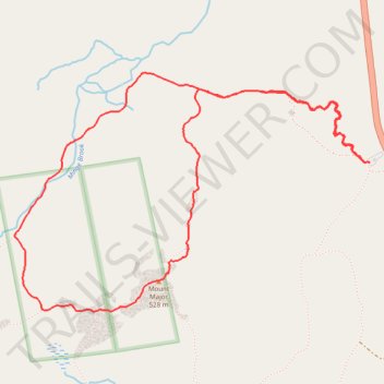
Mount Major Loop
Via Mount Major Trail and Brook Trail in Mount Major State Forest #Hiking #Loop #Mountain #Forest #River #Lake
- Distance: 4.0 mi
- Elevation gain: 1,109 ft
- Maximum elevation: 1,755 ft
- Elevation loss: 1,112 ft
- Minimum elevation: 673 ft
- Moving time: 1 h 48 m
- Moving speed: 2.2 mph
- Maximum speed: 3.8 mph
- Total time: 2 h 10 m
- Global speed: 1.9 mph
Interactive trail map
Make a donation
Gear up for your next adventure:
As an Amazon Associate, this site earns from qualifying purchases at no extra cost to you.
Trail profile
- Distance: 4.0 mi
- Elevation gain: 1,109 ft
- Maximum elevation: 1,755 ft
- Elevation loss: 1,112 ft
- Minimum elevation: 673 ft
- Moving time: 1 h 48 m
- Moving speed: 2.2 mph
- Maximum speed: 3.8 mph
- Total time: 2 h 10 m
- Global speed: 1.9 mph
Make a donation
Gear up for your next adventure:
As an Amazon Associate, this site earns from qualifying purchases at no extra cost to you.
About this trail
Name: Mount Major Loop trail, distance, elevation, map, profile, GPS track
Coordinates: 43.51224 -71.29657 43.52336 -71.27377
Topography: Belknap County topographic map, elevation, terrain
Make a donation
Gear up for your next adventure:
As an Amazon Associate, this site earns from qualifying purchases at no extra cost to you.
Other hiking, mountain biking, running and outdoor activity trails
Click on a trail to view its statistics, map and profile.
Mount Major Trail and Brook Trail Loop in Major Mountain State Forest
United States > New Hampshire > Belknap County > Alton > Mount Major
The Mount Major Trail and Brook Trail Loop offers an enjoyable and scenic hike suitable for most skill levels. The route features breathtaking panoramic views of Lake Winnipesaukee and the White Mountains from the summit, with opportunities to admire the lush forest, rocky outcroppings, and interesting…
Distance: 4.1 mi • Elevation gain: 1,129 ft • Maximum elevation: 1,768 ft
Mount Major Trail and Brook Trail Loop in Mount Major State Forest
United States > New Hampshire > Belknap County > Alton > Mount Major
The Mount Major Trail and Brook Trail Loop in Mount Major State Forest offers a rewarding hike with spectacular views of the surrounding lakes and forested landscape. The trail provides hikers with an opportunity to explore varied terrain, from rocky sections to lush woodland, all while ascending the peak for…
Distance: 4.1 mi • Elevation gain: 1,099 ft • Maximum elevation: 1,759 ft