Make a donation
Gear up for your next adventure:
As an Amazon Associate, this site earns from qualifying purchases at no extra cost to you.
Triple Falls and High Falls Loop
Interactive trail map
Make a donation
Gear up for your next adventure:
As an Amazon Associate, this site earns from qualifying purchases at no extra cost to you.
Trail profile
- Distance: 3.1 mi
- Elevation gain: 341 ft
- Maximum elevation: 2,579 ft
- Elevation loss: 341 ft
- Minimum elevation: 2,372 ft
- Moving time: 1 h 8 m
- Moving speed: 2.7 mph
- Maximum speed: 3.9 mph
- Total time: 1 h 30 m
- Global speed: 2.0 mph
Make a donation
Gear up for your next adventure:
As an Amazon Associate, this site earns from qualifying purchases at no extra cost to you.
About this trail
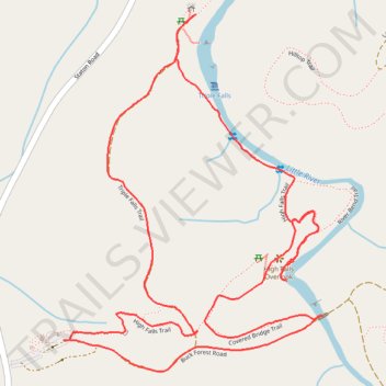
Name: Triple Falls and High Falls Loop trail, distance, elevation, map, profile, GPS track
Start: Buck Forest Road, Transylvania County, North Carolina, 28718, United States (35.19166 -82.62178)
End: Buck Forest Road, Transylvania County, North Carolina, 28718, United States (35.19167 -82.62154)
Coordinates: 35.19084 -82.62178 35.20031 -82.61335
Topography: Transylvania County topographic map, elevation, terrain
Make a donation
Gear up for your next adventure:
As an Amazon Associate, this site earns from qualifying purchases at no extra cost to you.
Other hiking, mountain biking, running and outdoor activity trails
Click on a trail to view its statistics, map and profile.
Triple Falls Trail and High Falls Trail in Dupont State Recreational Forest
United States > North Carolina > Transylvania County
The Triple Falls and High Falls Trails in Dupont State Recreational Forest offer hikers a scenic journey through lush forests, leading to the impressive Triple Falls—a three-tiered cascade featured in films like "The Hunger Games"—and culminating at the majestic High Falls, a 150-foot waterfall that slides…
Distance: 2.3 mi • Elevation gain: 358 ft • Maximum elevation: 2,500 ft
Triple Falls and High Falls Trails Loop in Dupont State Recreational Forest
United States > North Carolina > Transylvania County
The Triple Falls and High Falls Trails Loop in Dupont State Recreational Forest offers hikers captivating views of two prominent waterfalls. Along the trail, you'll first encounter Triple Falls, a stunning three-tiered cascade, followed by High Falls, a majestic waterfall that plunges over a wide rock face.…
Distance: 3.2 mi • Elevation gain: 344 ft • Maximum elevation: 2,579 ft
Hooker Falls Trail and Triple Falls Trail
United States > North Carolina > Transylvania County
Distance: 1.8 mi • Elevation gain: 269 ft • Maximum elevation: 2,375 ft