Thank you for supporting this site ❤️
Make a donation
Make a donation
Gear up for your next adventure:
As an Amazon Associate, this site earns from qualifying purchases at no extra cost to you.
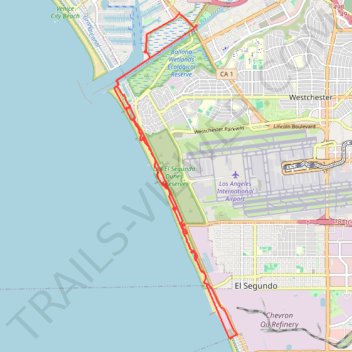
Dockweiler State Beach bike paths
- Distance: 14.4 mi
- Elevation gain: 623 ft
- Maximum elevation: 112 ft
- Elevation loss: 623 ft
- Minimum elevation: 0 ft
- Moving time: 1 h 22 m
- Moving speed: 10.5 mph
- Maximum speed: 23.1 mph
- Total time: 1 h 23 m
- Global speed: 10.4 mph
Interactive trail map
Thank you for supporting this site ❤️
Make a donation
Make a donation
Gear up for your next adventure:
As an Amazon Associate, this site earns from qualifying purchases at no extra cost to you.
Trail profile
- Distance: 14.4 mi
- Elevation gain: 623 ft
- Maximum elevation: 112 ft
- Elevation loss: 623 ft
- Minimum elevation: 0 ft
- Moving time: 1 h 22 m
- Moving speed: 10.5 mph
- Maximum speed: 23.1 mph
- Total time: 1 h 23 m
- Global speed: 10.4 mph
Thank you for supporting this site ❤️
Make a donation
Make a donation
Gear up for your next adventure:
As an Amazon Associate, this site earns from qualifying purchases at no extra cost to you.
About this trail
Name: Dockweiler State Beach bike paths trail, distance, elevation, map, profile, GPS track
Coordinates: 33.90497 -118.45427 33.97882 -118.42075
Topography: Los Angeles topographic map, elevation, terrain
Thank you for supporting this site ❤️
Make a donation
Make a donation
Gear up for your next adventure:
As an Amazon Associate, this site earns from qualifying purchases at no extra cost to you.
Other hiking, mountain biking, running and outdoor activity trails
Click on a trail to view its statistics, map and profile.