Make a donation
Gear up for your next adventure:
As an Amazon Associate, this site earns from qualifying purchases at no extra cost to you.
Mount Monadnock and Monte Rosa loop via Smith Trail
- Distance: 5.2 mi
- Elevation gain: 1,696 ft
- Maximum elevation: 3,117 ft
- Elevation loss: 1,699 ft
- Minimum elevation: 1,506 ft
- Moving time: 2 h 58 m
- Moving speed: 1.8 mph
- Maximum speed: 6.1 mph
- Total time: 3 h 53 m
- Global speed: 1.3 mph
Interactive trail map
Make a donation
Gear up for your next adventure:
As an Amazon Associate, this site earns from qualifying purchases at no extra cost to you.
Trail profile
- Distance: 5.2 mi
- Elevation gain: 1,696 ft
- Maximum elevation: 3,117 ft
- Elevation loss: 1,699 ft
- Minimum elevation: 1,506 ft
- Moving time: 2 h 58 m
- Moving speed: 1.8 mph
- Maximum speed: 6.1 mph
- Total time: 3 h 53 m
- Global speed: 1.3 mph
Make a donation
Gear up for your next adventure:
As an Amazon Associate, this site earns from qualifying purchases at no extra cost to you.
About this trail
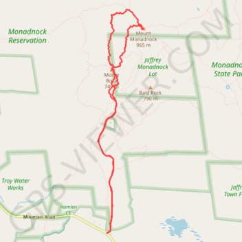
Name: Mount Monadnock and Monte Rosa loop via Smith Trail trail, distance, elevation, map, profile, GPS track
Coordinates: 42.83524 -72.11598 42.86388 -72.10810
Topography: Cheshire County topographic map, elevation, terrain
Make a donation
Gear up for your next adventure:
As an Amazon Associate, this site earns from qualifying purchases at no extra cost to you.
Other hiking, mountain biking, running and outdoor activity trails
Click on a trail to view its statistics, map and profile.
Bald Rock, Paradise Valley trail and others in the Monadnock State Park
United States > New Hampshire > Cheshire County > Jaffrey
Distance: 4.7 mi • Elevation gain: 1,804 ft • Maximum elevation: 2,920 ft
Lost Paradise Valley Loop Trail
United States > New Hampshire > Cheshire County > Jaffrey
Distance: 4.8 mi • Elevation gain: 1,804 ft • Maximum elevation: 2,920 ft
Lost Smith Trail
United States > New Hampshire > Cheshire County > Jaffrey
Distance: 5.3 mi • Elevation gain: 1,660 ft • Maximum elevation: 3,117 ft
Make a donation
Gear up for your next adventure:
As an Amazon Associate, this site earns from qualifying purchases at no extra cost to you.