Thank you for supporting this site ❤️
Make a donation
Make a donation
Gear up for your next adventure:
As an Amazon Associate, this site earns from qualifying purchases at no extra cost to you.
Woodlands Legacy Field Park trails
- Distance: 5.3 mi
- Elevation gain: 581 ft
- Maximum elevation: 571 ft
- Elevation loss: 577 ft
- Minimum elevation: 397 ft
- Moving time: 1 h 30 m
- Moving speed: 3.5 mph
- Maximum speed: 8.4 mph
- Total time: 1 h 30 m
- Global speed: 3.5 mph
Interactive trail map
Thank you for supporting this site ❤️
Make a donation
Make a donation
Gear up for your next adventure:
As an Amazon Associate, this site earns from qualifying purchases at no extra cost to you.
Trail profile
- Distance: 5.3 mi
- Elevation gain: 581 ft
- Maximum elevation: 571 ft
- Elevation loss: 577 ft
- Minimum elevation: 397 ft
- Moving time: 1 h 30 m
- Moving speed: 3.5 mph
- Maximum speed: 8.4 mph
- Total time: 1 h 30 m
- Global speed: 3.5 mph
Thank you for supporting this site ❤️
Make a donation
Make a donation
Gear up for your next adventure:
As an Amazon Associate, this site earns from qualifying purchases at no extra cost to you.
About this trail
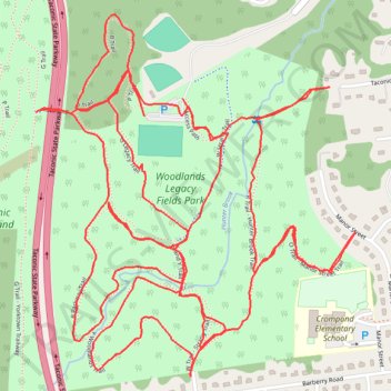
Name: Woodlands Legacy Field Park trails trail, distance, elevation, map, profile, GPS track
Coordinates: 41.30329 -73.82463 41.31197 -73.81444
Topography: Westchester County topographic map, elevation, terrain
Thank you for supporting this site ❤️
Make a donation
Make a donation
Gear up for your next adventure:
As an Amazon Associate, this site earns from qualifying purchases at no extra cost to you.
Other hiking, mountain biking, running and outdoor activity trails
Click on a trail to view its statistics, map and profile.