Thank you for supporting this site ❤️
Make a donation
Make a donation
Gear up for your next adventure:
As an Amazon Associate, this site earns from qualifying purchases at no extra cost to you.
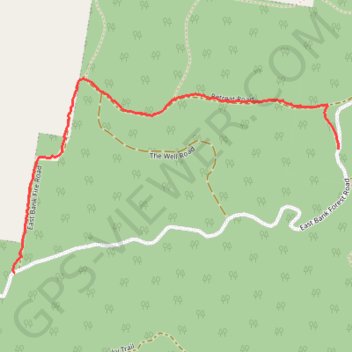
Retreat road
Evening Walk
- Distance: 1.6 mi
- Elevation gain: 358 ft
- Maximum elevation: 725 ft
- Elevation loss: 220 ft
- Minimum elevation: 377 ft
- Moving time: 37 m 43 s
- Moving speed: 2.6 mph
- Maximum speed: 5.8 mph
- Total time: 38 m 46 s
- Global speed: 2.5 mph
Interactive trail map
Thank you for supporting this site ❤️
Make a donation
Make a donation
Gear up for your next adventure:
As an Amazon Associate, this site earns from qualifying purchases at no extra cost to you.
Trail profile
- Distance: 1.6 mi
- Elevation gain: 358 ft
- Maximum elevation: 725 ft
- Elevation loss: 220 ft
- Minimum elevation: 377 ft
- Moving time: 37 m 43 s
- Moving speed: 2.6 mph
- Maximum speed: 5.8 mph
- Total time: 38 m 46 s
- Global speed: 2.5 mph
Thank you for supporting this site ❤️
Make a donation
Make a donation
Gear up for your next adventure:
As an Amazon Associate, this site earns from qualifying purchases at no extra cost to you.
About this trail
Name: Retreat road trail, distance, elevation, map, profile, GPS track
Coordinates: -30.21115 153.04088 -30.20296 153.05675
Thank you for supporting this site ❤️
Make a donation
Make a donation
Gear up for your next adventure:
As an Amazon Associate, this site earns from qualifying purchases at no extra cost to you.