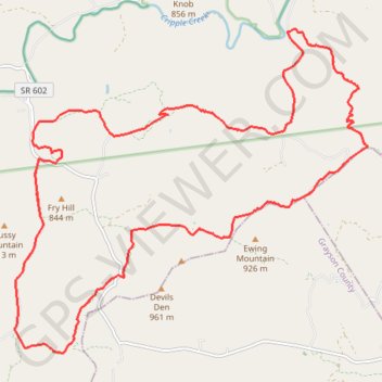
Cripple Creek - Virginia Highlands Horse Trail
- Distance: 17.0 mi
- Elevation gain: 2,310 ft
- Maximum elevation: 3,107 ft
- Elevation loss: 2,303 ft
- Minimum elevation: 2,126 ft
Interactive trail map
Trail profile
- Distance: 17.0 mi
- Elevation gain: 2,310 ft
- Maximum elevation: 3,107 ft
- Elevation loss: 2,303 ft
- Minimum elevation: 2,126 ft
About this trail
Name: Cripple Creek - Virginia Highlands Horse Trail trail, distance, elevation, map, profile, GPS track
Start: Cripple Creek Road, Shiloh, Wythe County, Virginia, 24322, United States (36.81353 -81.09403)
End: Cripple Creek Road, Shiloh, Wythe County, Virginia, 24322, United States (36.81351 -81.09369)
Coordinates: 36.78088 -81.10151 36.83389 -81.02926
Topography: Wythe County topographic map, elevation, terrain
Other hiking, mountain biking, running and outdoor activity trails
Click on a trail to view its statistics, map and profile.
C C Camp Road to Hussy Moutain Horse Campground
United States > Virginia > Wythe County > Shiloh
Distance: 14.0 mi • Elevation gain: 2,874 ft • Maximum elevation: 3,829 ft