Make a donation
Gear up for your next adventure:
As an Amazon Associate, this site earns from qualifying purchases at no extra cost to you.
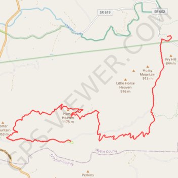
C C Camp Road to Hussy Moutain Horse Campground
- Distance: 14.0 mi
- Elevation gain: 2,874 ft
- Maximum elevation: 3,829 ft
- Elevation loss: 2,254 ft
- Minimum elevation: 2,241 ft
Interactive trail map
Make a donation
Gear up for your next adventure:
As an Amazon Associate, this site earns from qualifying purchases at no extra cost to you.
Trail profile
- Distance: 14.0 mi
- Elevation gain: 2,874 ft
- Maximum elevation: 3,829 ft
- Elevation loss: 2,254 ft
- Minimum elevation: 2,241 ft
Make a donation
Gear up for your next adventure:
As an Amazon Associate, this site earns from qualifying purchases at no extra cost to you.
About this trail
Name: C C Camp Road to Hussy Moutain Horse Campground trail, distance, elevation, map, profile, GPS track
Start: Cripple Creek Road, Shiloh, Wythe County, Virginia, 24322, United States (36.81376 -81.09381)
Coordinates: 36.77129 -81.17448 36.81405 -81.09169
Topography: Wythe County topographic map, elevation, terrain
Make a donation
Gear up for your next adventure:
As an Amazon Associate, this site earns from qualifying purchases at no extra cost to you.
Other hiking, mountain biking, running and outdoor activity trails
Click on a trail to view its statistics, map and profile.
Cripple Creek - Virginia Highlands Horse Trail
United States > Virginia > Wythe County > Shiloh
Distance: 17.0 mi • Elevation gain: 2,310 ft • Maximum elevation: 3,107 ft