Thank you for supporting this site ❤️
Make a donation
Make a donation
Gear up for your next adventure:
As an Amazon Associate, this site earns from qualifying purchases at no extra cost to you.
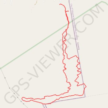
De Wildt Peglarae trail
- Distance: 5.8 mi
- Elevation gain: 1,220 ft
- Maximum elevation: 5,318 ft
- Elevation loss: 1,207 ft
- Minimum elevation: 4,367 ft
- Moving time: 3 h 11 m
- Moving speed: 1.8 mph
- Maximum speed: 5.3 mph
- Total time: 4 h 10 m
- Global speed: 1.4 mph
Interactive trail map
Thank you for supporting this site ❤️
Make a donation
Make a donation
Gear up for your next adventure:
As an Amazon Associate, this site earns from qualifying purchases at no extra cost to you.
Trail profile
- Distance: 5.8 mi
- Elevation gain: 1,220 ft
- Maximum elevation: 5,318 ft
- Elevation loss: 1,207 ft
- Minimum elevation: 4,367 ft
- Moving time: 3 h 11 m
- Moving speed: 1.8 mph
- Maximum speed: 5.3 mph
- Total time: 4 h 10 m
- Global speed: 1.4 mph
Thank you for supporting this site ❤️
Make a donation
Make a donation
Gear up for your next adventure:
As an Amazon Associate, this site earns from qualifying purchases at no extra cost to you.
About this trail
Name: De Wildt Peglarae trail trail, distance, elevation, map, profile, GPS track
Coordinates: -25.69515 27.94293 -25.67435 27.95775
Thank you for supporting this site ❤️
Make a donation
Make a donation
Gear up for your next adventure:
As an Amazon Associate, this site earns from qualifying purchases at no extra cost to you.