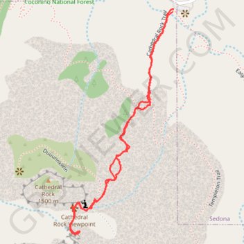
Cathedral Rock Viewpoint via Cathedral Rock Trail in Coconino National Forest
The Cathedral Rock Trail in Sedona is a thrilling hike that rewards you with stunning views of the iconic red rock formations. While the scramble can be a bit tricky, it's all part of the adventure and adds to the excitement of reaching the top. Just remember to wear sturdy shoes for the best grip, and take your time to enjoy the beautiful surroundings along the way! #Hiking #Mountain #Nature
- Distance: 1.4 mi
- Elevation gain: 774 ft
- Maximum elevation: 4,826 ft
- Elevation loss: 778 ft
- Minimum elevation: 4,049 ft
- Moving time: 58 m 54 s
- Moving speed: 1.4 mph
- Maximum speed: 3.0 mph
- Total time: 1 h 48 m
- Global speed: 0.8 mph
Interactive trail map
Trail profile
- Distance: 1.4 mi
- Elevation gain: 774 ft
- Maximum elevation: 4,826 ft
- Elevation loss: 778 ft
- Minimum elevation: 4,049 ft
- Moving time: 58 m 54 s
- Moving speed: 1.4 mph
- Maximum speed: 3.0 mph
- Total time: 1 h 48 m
- Global speed: 0.8 mph
About this trail
Name: Cathedral Rock Viewpoint via Cathedral Rock Trail in Coconino National Forest trail, distance, elevation, map, profile, GPS track
Start: Cathedral Rock Trail, Yavapai County, Arizona, 86336, United States (34.82514 -111.78863)
End: Cathedral Rock Trail, Yavapai County, Arizona, 86336, United States (34.82506 -111.78864)
Coordinates: 34.81840 -111.79240 34.82514 -111.78863
Topography: Yavapai County topographic map, elevation, terrain
Other hiking, mountain biking, running and outdoor activity trails
Click on a trail to view its statistics, map and profile.
Cathedral Rock Trail via Baldwin Trail and Templeton Trail in Coconino National Forest
United States > Arizona > Yavapai County > Baldwins Crossing
The Cathedral Rock Trail via Baldwin and Templeton Trails offers a peaceful and scenic approach to one of Sedona’s most iconic landmarks. Hikers follow a path lined with red rock formations, pinyon pines, and junipers, with occasional views of Oak Creek's lush greenery adding contrast to the desert…
Distance: 3.8 mi • Elevation gain: 902 ft • Maximum elevation: 4,721 ft
Cathedral Rock Loop
United States > Arizona > Coconino County
Loop hike to Cathedral Rock Viewpoint via Slim Shady Trail, Templeton Trail, Cathedral Rock Trail, Oak Creek, Baldwin Trail, Hiline Trail and Yavapai Vista in the Coconino National Forest. #Hiking #Loop #Rock #Nature #Forest #River #Mountain
Distance: 8.9 mi • Elevation gain: 2,244 ft • Maximum elevation: 4,829 ft