Make a donation
Gear up for your next adventure:
As an Amazon Associate, this site earns from qualifying purchases at no extra cost to you.
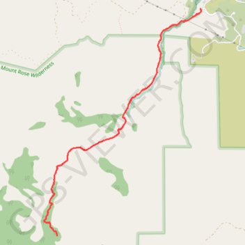
Hunter Creek Trail in Mount Rose Wilderness
The Hunter Creek Trail is a delightful hike that takes you through diverse landscapes. Starting out under the open sun, the trail quickly transitions into a serene forest where you can enjoy the nature leading up to a stunning waterfall. This peaceful spot is perfect for a break, making the hike a rewarding experience for the whole family. #Hiking #Mountain #River #Waterfall #Forest #Nature
- Distance: 6.1 mi
- Elevation gain: 1,322 ft
- Maximum elevation: 6,161 ft
- Elevation loss: 1,322 ft
- Minimum elevation: 4,980 ft
- Moving time: 3 h 5 m
- Moving speed: 2.0 mph
- Maximum speed: 4.7 mph
- Total time: 3 h 35 m
- Global speed: 1.7 mph
Interactive trail map
Make a donation
Gear up for your next adventure:
As an Amazon Associate, this site earns from qualifying purchases at no extra cost to you.
Trail profile
- Distance: 6.1 mi
- Elevation gain: 1,322 ft
- Maximum elevation: 6,161 ft
- Elevation loss: 1,322 ft
- Minimum elevation: 4,980 ft
- Moving time: 3 h 5 m
- Moving speed: 2.0 mph
- Maximum speed: 4.7 mph
- Total time: 3 h 35 m
- Global speed: 1.7 mph
Make a donation
Gear up for your next adventure:
As an Amazon Associate, this site earns from qualifying purchases at no extra cost to you.
About this trail
Name: Hunter Creek Trail in Mount Rose Wilderness trail, distance, elevation, map, profile, GPS track
Start: Woodchuck Circle, Washoe County, Nevada, 89523, United States (39.49368 -119.89412)
End: Woodchuck Circle, Washoe County, Nevada, 89523, United States (39.49368 -119.89409)
Coordinates: 39.46479 -119.91991 39.49368 -119.89395
Topography: Washoe County topographic map, elevation, terrain
Make a donation
Gear up for your next adventure:
As an Amazon Associate, this site earns from qualifying purchases at no extra cost to you.
Other hiking, mountain biking, running and outdoor activity trails
Click on a trail to view its statistics, map and profile.
Hunter Footill Road Loop in Humboldt-Toiyabe National Forest
United States > Nevada > Washoe County
Distance: 13.1 mi • Elevation gain: 1,798 ft • Maximum elevation: 5,643 ft
Day 1: Home to dispersed camping 60 mi E of Austin, NV
United States > Nevada > Washoe County > Reno
Distance: 129.5 mi • Elevation gain: 3,320 ft • Maximum elevation: 5,128 ft