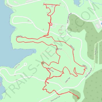
Cedar Hill State Park - Talala Trail
- Distance: 4.9 mi
- Elevation gain: 259 ft
- Maximum elevation: 640 ft
- Elevation loss: 262 ft
- Minimum elevation: 541 ft
- Moving time: 1 h 39 m
- Moving speed: 2.9 mph
- Maximum speed: 4.1 mph
- Total time: 1 h 42 m
- Global speed: 2.9 mph
Interactive trail map
Trail profile
- Distance: 4.9 mi
- Elevation gain: 259 ft
- Maximum elevation: 640 ft
- Elevation loss: 262 ft
- Minimum elevation: 541 ft
- Moving time: 1 h 39 m
- Moving speed: 2.9 mph
- Maximum speed: 4.1 mph
- Total time: 1 h 42 m
- Global speed: 2.9 mph
About this trail
Name: Cedar Hill State Park - Talala Trail trail, distance, elevation, map, profile, GPS track
Start: Talala Trail, Cedar Hill, Dallas County, Texas, 75054, United States (32.62161 -96.98657)
End: Talala Trail, Cedar Hill, Dallas County, Texas, 75054, United States (32.62190 -96.98633)
Coordinates: 32.61347 -96.99112 32.62435 -96.98161
Topography: Dallas County topographic map, elevation, terrain
Other hiking, mountain biking, running and outdoor activity trails
Click on a trail to view its statistics, map and profile.
Cedar Hill State Park Duck Pond Trail and part of the Plum Valley trail
United States > Texas > Dallas County > Cedar Hill
Distance: 1.8 mi • Elevation gain: 131 ft • Maximum elevation: 636 ft