Make a donation
Gear up for your next adventure:
As an Amazon Associate, this site earns from qualifying purchases at no extra cost to you.
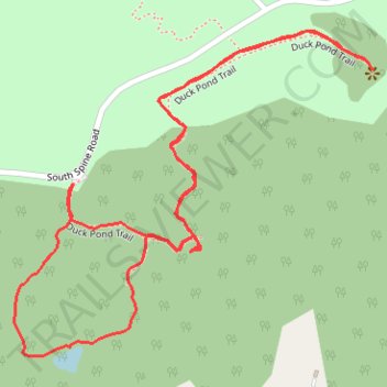
Cedar Hill State Park Duck Pond Trail and part of the Plum Valley trail
- Distance: 1.8 mi
- Elevation gain: 131 ft
- Maximum elevation: 636 ft
- Elevation loss: 131 ft
- Minimum elevation: 545 ft
- Moving time: 36 m 24 s
- Moving speed: 3.0 mph
- Maximum speed: 3.6 mph
- Total time: 37 m 31 s
- Global speed: 2.9 mph
Interactive trail map
Make a donation
Gear up for your next adventure:
As an Amazon Associate, this site earns from qualifying purchases at no extra cost to you.
Trail profile
- Distance: 1.8 mi
- Elevation gain: 131 ft
- Maximum elevation: 636 ft
- Elevation loss: 131 ft
- Minimum elevation: 545 ft
- Moving time: 36 m 24 s
- Moving speed: 3.0 mph
- Maximum speed: 3.6 mph
- Total time: 37 m 31 s
- Global speed: 2.9 mph
Make a donation
Gear up for your next adventure:
As an Amazon Associate, this site earns from qualifying purchases at no extra cost to you.
About this trail
Name: Cedar Hill State Park Duck Pond Trail and part of the Plum Valley trail trail, distance, elevation, map, profile, GPS track
Start: Duck Pond Trail, Cedar Hill, Dallas County, Texas, 75054, United States (32.61154 -96.98874)
End: South Spine Road, Cedar Hill, Dallas County, Texas, 75054, United States (32.61159 -96.98874)
Coordinates: 32.60861 -96.98993 32.61421 -96.98262
Topography: Dallas County topographic map, elevation, terrain
Make a donation
Gear up for your next adventure:
As an Amazon Associate, this site earns from qualifying purchases at no extra cost to you.
Other hiking, mountain biking, running and outdoor activity trails
Click on a trail to view its statistics, map and profile.
Cedar Hill State Park - Talala Trail
United States > Texas > Dallas County > Cedar Hill
Distance: 4.9 mi • Elevation gain: 259 ft • Maximum elevation: 640 ft