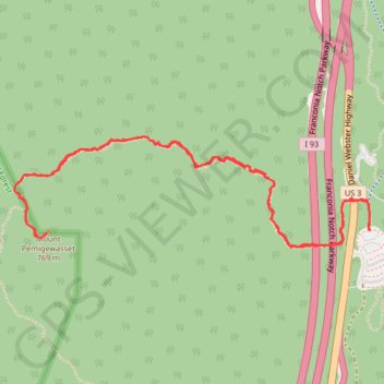
Mount Pemigewasset Trail in Franconia Notch State Park
The Mount Pemigewasset Trail offers a relatively short but rewarding hike through the forest with beautiful views as you ascend. Along the way, hikers pass through tunnels beneath the highway and climb steady, rocky paths that lead to a broad summit. From the peak, the panoramic views extend across the surrounding mountains, including the Kinsman Ridge and the iconic peaks of the White Mountains, with opportunities to spot local wildlife such as chipmunks and various birds. #Hiking #Mountain #Forest #Nature
- Distance: 3.5 mi
- Elevation gain: 1,227 ft
- Maximum elevation: 2,484 ft
- Elevation loss: 1,227 ft
- Minimum elevation: 1,342 ft
- Moving time: 2 h 1 m
- Moving speed: 1.7 mph
- Maximum speed: 7.2 mph
- Total time: 3 h 15 m
- Global speed: 1.1 mph
Interactive trail map
Trail profile
- Distance: 3.5 mi
- Elevation gain: 1,227 ft
- Maximum elevation: 2,484 ft
- Elevation loss: 1,227 ft
- Minimum elevation: 1,342 ft
- Moving time: 2 h 1 m
- Moving speed: 1.7 mph
- Maximum speed: 7.2 mph
- Total time: 3 h 15 m
- Global speed: 1.1 mph
About this trail
Name: Mount Pemigewasset Trail in Franconia Notch State Park trail, distance, elevation, map, profile, GPS track
Coordinates: 44.09715 -71.70080 44.10149 -71.68153
Topography: Grafton County topographic map, elevation, terrain
Other hiking, mountain biking, running and outdoor activity trails
Click on a trail to view its statistics, map and profile.