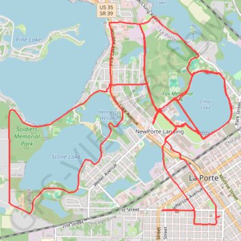
New Bike lanes and construction in La Porte
- Distance: 18.7 mi
- Elevation gain: 469 ft
- Maximum elevation: 856 ft
- Elevation loss: 469 ft
- Minimum elevation: 787 ft
- Moving time: 1 h 26 m
- Moving speed: 13.0 mph
- Maximum speed: 24.7 mph
- Total time: 1 h 27 m
- Global speed: 12.8 mph
Interactive trail map
Trail profile
About this trail
Name: New Bike lanes and construction in La Porte trail, distance, elevation, map, profile, GPS track
Start: 109, 2nd Street, La Porte, LaPorte County, Indiana, 46350, United States (41.60567 -86.71993)
End: 109, 2nd Street, La Porte, LaPorte County, Indiana, 46350, United States (41.60575 -86.71972)
Coordinates: 41.60470 -86.75544 41.63100 -86.71772
Topography: LaPorte County topographic map, elevation, terrain
Other hiking, mountain biking, running and outdoor activity trails
Click on a trail to view its statistics, map and profile.
Soldiers Memorial Park MTB Trails
United States > Indiana > LaPorte County > La Porte
Distance: 7.0 mi • Elevation gain: 253 ft • Maximum elevation: 850 ft
Clear Lake Greenway in Fox Memorial Park
United States > Indiana > LaPorte County > La Porte
Distance: 0.9 mi • Elevation gain: 33 ft • Maximum elevation: 823 ft