Kay Beltline - Rosedale Valley - Don Valley - Prohibition
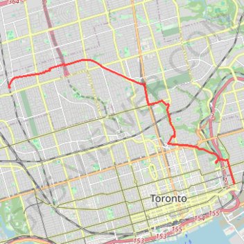
Interactive trail map
Trail profile
- Distance: 8.9 mi
- Elevation gain: 328 ft
- Maximum elevation: 594 ft
- Elevation loss: 568 ft
- Minimum elevation: 253 ft
About this trail
Name: Kay Beltline - Rosedale Valley - Don Valley - Prohibition trail, distance, elevation, map, profile, GPS track
Coordinates: 43.65880 -79.46535 43.70476 -79.34983
Other hiking, mountain biking, running and outdoor activity trails
Click on a trail to view its statistics, map and profile.
Biidaasige Park and Tommy Thompson Park Loop Ride
Distance: 12.7 mi • Elevation gain: 220 ft • Maximum elevation: 269 ft
Brampton - Scarborough
Canada > Ontario > Peel Region > Brampton
Lake Ontario. #Bike #Brampton #Scarborough #Toronto #Ontario
Distance: 45.5 mi • Elevation gain: 1,870 ft • Maximum elevation: 604 ft
Toronto - Oshawa
Canada > Ontario > Old Toronto
#Bike
Distance: 41.8 mi • Elevation gain: 1,499 ft • Maximum elevation: 600 ft
Toronto Cycling
Distance: 24.3 mi • Elevation gain: 1,168 ft • Maximum elevation: 407 ft