Thank you for supporting this site ❤️
Make a donation
Make a donation
Gear up for your next adventure:
As an Amazon Associate, this site earns from qualifying purchases at no extra cost to you.
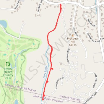
Kate Kennard Trail
- Distance: 1.9 mi
- Elevation gain: 157 ft
- Maximum elevation: 420 ft
- Elevation loss: 157 ft
- Minimum elevation: 305 ft
- Moving time: 36 m 9 s
- Moving speed: 3.2 mph
- Maximum speed: 5.8 mph
- Total time: 38 m 17 s
- Global speed: 3.0 mph
Interactive trail map
Thank you for supporting this site ❤️
Make a donation
Make a donation
Gear up for your next adventure:
As an Amazon Associate, this site earns from qualifying purchases at no extra cost to you.
Trail profile
- Distance: 1.9 mi
- Elevation gain: 157 ft
- Maximum elevation: 420 ft
- Elevation loss: 157 ft
- Minimum elevation: 305 ft
- Moving time: 36 m 9 s
- Moving speed: 3.2 mph
- Maximum speed: 5.8 mph
- Total time: 38 m 17 s
- Global speed: 3.0 mph
Thank you for supporting this site ❤️
Make a donation
Make a donation
Gear up for your next adventure:
As an Amazon Associate, this site earns from qualifying purchases at no extra cost to you.
About this trail
Name: Kate Kennard Trail trail, distance, elevation, map, profile, GPS track
Coordinates: 41.12174 -73.84522 41.13337 -73.84222
Topography: Westchester County topographic map, elevation, terrain
Thank you for supporting this site ❤️
Make a donation
Make a donation
Gear up for your next adventure:
As an Amazon Associate, this site earns from qualifying purchases at no extra cost to you.
Other hiking, mountain biking, running and outdoor activity trails
Click on a trail to view its statistics, map and profile.