Make a donation
Gear up for your next adventure:
As an Amazon Associate, this site earns from qualifying purchases at no extra cost to you.
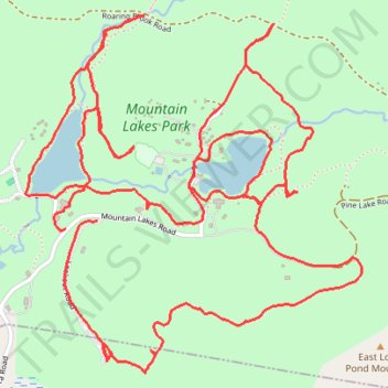
Mountain Lakes Park trails
- Distance: 5.9 mi
- Elevation gain: 820 ft
- Maximum elevation: 909 ft
- Elevation loss: 869 ft
- Minimum elevation: 600 ft
- Moving time: 2 h 8 m
- Moving speed: 2.8 mph
- Maximum speed: 7.4 mph
- Total time: 2 h 18 m
- Global speed: 2.6 mph
Interactive trail map
Make a donation
Gear up for your next adventure:
As an Amazon Associate, this site earns from qualifying purchases at no extra cost to you.
Trail profile
- Distance: 5.9 mi
- Elevation gain: 820 ft
- Maximum elevation: 909 ft
- Elevation loss: 869 ft
- Minimum elevation: 600 ft
- Moving time: 2 h 8 m
- Moving speed: 2.8 mph
- Maximum speed: 7.4 mph
- Total time: 2 h 18 m
- Global speed: 2.6 mph
Make a donation
Gear up for your next adventure:
As an Amazon Associate, this site earns from qualifying purchases at no extra cost to you.
About this trail
Name: Mountain Lakes Park trails trail, distance, elevation, map, profile, GPS track
Coordinates: 41.30312 -73.57032 41.31519 -73.55526
Topography: Westchester County topographic map, elevation, terrain
Make a donation
Gear up for your next adventure:
As an Amazon Associate, this site earns from qualifying purchases at no extra cost to you.
Other hiking, mountain biking, running and outdoor activity trails
Click on a trail to view its statistics, map and profile.
Mountain Lakes Park loop
United States > New York > Westchester County > Town of North Salem
Distance: 6.0 mi • Elevation gain: 814 ft • Maximum elevation: 978 ft