Thank you for supporting this site ❤️
Make a donation
Make a donation
Gear up for your next adventure:
As an Amazon Associate, this site earns from qualifying purchases at no extra cost to you.
Sailor's Falls loop - Lake Jubilee - Daylesford
Interactive trail map
Thank you for supporting this site ❤️
Make a donation
Make a donation
Gear up for your next adventure:
As an Amazon Associate, this site earns from qualifying purchases at no extra cost to you.
Trail profile
- Distance: 10.5 mi
- Elevation gain: 1,191 ft
- Maximum elevation: 2,129 ft
- Elevation loss: 1,191 ft
- Minimum elevation: 1,677 ft
Thank you for supporting this site ❤️
Make a donation
Make a donation
Gear up for your next adventure:
As an Amazon Associate, this site earns from qualifying purchases at no extra cost to you.
About this trail
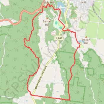
Name: Sailor's Falls loop - Lake Jubilee - Daylesford trail, distance, elevation, map, profile, GPS track
Coordinates: -37.39298 144.11549 -37.34715 144.14922
Thank you for supporting this site ❤️
Make a donation
Make a donation
Gear up for your next adventure:
As an Amazon Associate, this site earns from qualifying purchases at no extra cost to you.
Other hiking, mountain biking, running and outdoor activity trails
Click on a trail to view its statistics, map and profile.
Two Lakes Loop - Daylesford
Australia > Victoria > Daylesford
Distance: 5.3 mi • Elevation gain: 646 ft • Maximum elevation: 1,969 ft