Make a donation
Gear up for your next adventure:
As an Amazon Associate, this site earns from qualifying purchases at no extra cost to you.
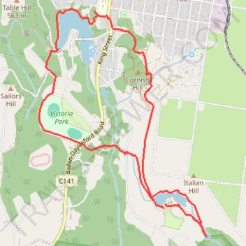
Two Lakes Loop - Daylesford
- Distance: 5.3 mi
- Elevation gain: 646 ft
- Maximum elevation: 1,969 ft
- Elevation loss: 653 ft
- Minimum elevation: 1,742 ft
- Moving time: 2 h 1 m
- Moving speed: 2.6 mph
- Maximum speed: 3.7 mph
- Total time: 2 h 39 m
- Global speed: 2.0 mph
Interactive trail map
Make a donation
Gear up for your next adventure:
As an Amazon Associate, this site earns from qualifying purchases at no extra cost to you.
Trail profile
- Distance: 5.3 mi
- Elevation gain: 646 ft
- Maximum elevation: 1,969 ft
- Elevation loss: 653 ft
- Minimum elevation: 1,742 ft
- Moving time: 2 h 1 m
- Moving speed: 2.6 mph
- Maximum speed: 3.7 mph
- Total time: 2 h 39 m
- Global speed: 2.0 mph
Make a donation
Gear up for your next adventure:
As an Amazon Associate, this site earns from qualifying purchases at no extra cost to you.
About this trail
Name: Two Lakes Loop - Daylesford trail, distance, elevation, map, profile, GPS track
Start: Lerderderg Track, Daylesford, Shire of Hepburn, Victoria, 3460, Australia (-37.36603 144.14892)
End: Lerderderg Track, Daylesford, Shire of Hepburn, Victoria, 3460, Australia (-37.36559 144.14926)
Coordinates: -37.36893 144.13306 -37.34583 144.15445
Make a donation
Gear up for your next adventure:
As an Amazon Associate, this site earns from qualifying purchases at no extra cost to you.
Other hiking, mountain biking, running and outdoor activity trails
Click on a trail to view its statistics, map and profile.