Marymere Falls
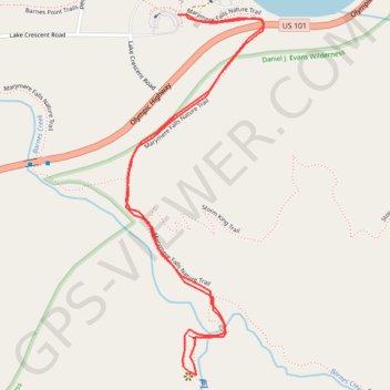
Interactive trail map
Trail profile
- Distance: 1.7 mi
- Elevation gain: 430 ft
- Maximum elevation: 945 ft
- Elevation loss: 430 ft
- Minimum elevation: 614 ft
About this trail
Name: Marymere Falls trail, distance, elevation, map, profile, GPS track
Start: Marymere Falls Nature Trail, Clallam County, Washington, United States (48.05808 -123.78914)
End: Marymere Falls Nature Trail, Clallam County, Washington, United States (48.05808 -123.78914)
Coordinates: 48.05047 -123.79078 48.05808 -123.78643
Topography: Clallam County topographic map, elevation, terrain
Other hiking, mountain biking, running and outdoor activity trails
Click on a trail to view its statistics, map and profile.
Mount Storm King Trail in Olympic National Park
United States > Washington > Clallam County
The Mount Storm King Trail offers a challenging yet rewarding hiking experience, leading adventurers through lush forests and up steep switchbacks. As hikers ascend, they are greeted by breathtaking views of Lake Crescent and the surrounding mountains, with the final stretch requiring the use of ropes for a…
Distance: 4.3 mi • Elevation gain: 2,247 ft • Maximum elevation: 2,608 ft