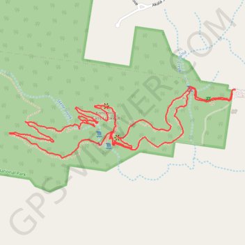
Kondalilla Falls - Rock Pools Loop
Kondalilla National Park. #Hiking #Loop #Kondalilla
- Distance: 2.9 mi
- Elevation gain: 873 ft
- Maximum elevation: 1,115 ft
- Elevation loss: 860 ft
- Minimum elevation: 659 ft
- Moving time: 1 h 32 m
- Moving speed: 1.9 mph
- Maximum speed: 4.2 mph
- Total time: 2 h 13 m
- Global speed: 1.3 mph
Interactive trail map
Trail profile
- Distance: 2.9 mi
- Elevation gain: 873 ft
- Maximum elevation: 1,115 ft
- Elevation loss: 860 ft
- Minimum elevation: 659 ft
- Moving time: 1 h 32 m
- Moving speed: 1.9 mph
- Maximum speed: 4.2 mph
- Total time: 2 h 13 m
- Global speed: 1.3 mph
About this trail
Name: Kondalilla Falls - Rock Pools Loop trail, distance, elevation, map, profile, GPS track
Coordinates: -26.67394 152.86091 -26.67091 152.87168
Other hiking, mountain biking, running and outdoor activity trails
Click on a trail to view its statistics, map and profile.
Lake Baroon - Kondalilla Falls
Australia > Queensland > Sunshine Coast Regional
Kondalilla National Park. #Hiking #Baroon #Kondalilla
Distance: 6.8 mi • Elevation gain: 1,909 ft • Maximum elevation: 1,119 ft
Imbil Jimna Kenilworth loop
Australia > Queensland > Tewantin
Distance: 134.2 mi • Elevation gain: 12,743 ft • Maximum elevation: 2,697 ft
Lake Baroon - Kondalilla Falls
Australia > Queensland > Sunshine Coast Regional
Kondalilla National Park. #Hiking #Baroon #Kondalilla
Distance: 6.0 mi • Elevation gain: 1,637 ft • Maximum elevation: 1,112 ft