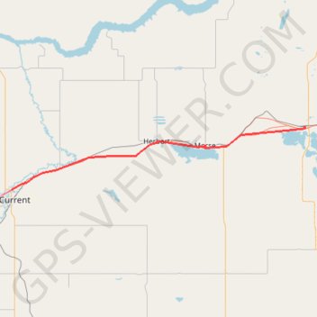
Swift Current - Chaplin
- Distance: 54.4 mi
- Elevation gain: 804 ft
- Maximum elevation: 2,539 ft
- Elevation loss: 1,017 ft
- Minimum elevation: 2,188 ft
Interactive trail map
Trail profile
- Distance: 54.4 mi
- Elevation gain: 804 ft
- Maximum elevation: 2,539 ft
- Elevation loss: 1,017 ft
- Minimum elevation: 2,188 ft
About this trail
Name: Swift Current - Chaplin trail, distance, elevation, map, profile, GPS track
End: Chaplin Village Campground, 1st Avenue, Chaplin, Saskatchewan, S0H 0V0, Canada (50.45788 -106.66231)
Coordinates: 50.30783 -107.76615 50.45939 -106.65759
Other hiking, mountain biking, running and outdoor activity trails
Click on a trail to view its statistics, map and profile.
Gull Lake - Swift Current
Canada > Saskatchewan > Gull Lake
Distance: 44.2 mi • Elevation gain: 883 ft • Maximum elevation: 2,625 ft
Gull Lake - Swift Current
Canada > Saskatchewan > Gull Lake
Distance: 38.0 mi • Elevation gain: 728 ft • Maximum elevation: 2,625 ft