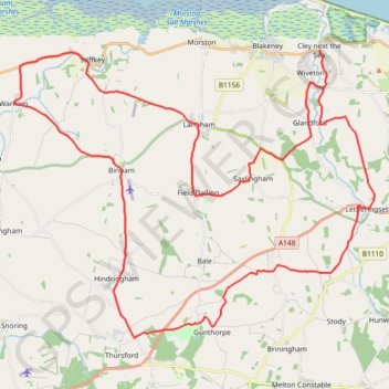
Cley next the Sea to Binham Bike Loop
#Bike #Loop #Road #Countryside #Nature
- Distance: 28.9 mi
- Elevation gain: 1,125 ft
- Maximum elevation: 312 ft
- Elevation loss: 1,125 ft
- Minimum elevation: 7 ft
Interactive trail map
Trail profile
- Distance: 28.9 mi
- Elevation gain: 1,125 ft
- Maximum elevation: 312 ft
- Elevation loss: 1,125 ft
- Minimum elevation: 7 ft
About this trail
Name: Cley next the Sea to Binham Bike Loop trail, distance, elevation, map, profile, GPS track
Coordinates: 52.86983 0.89749 52.95249 1.06910
Other hiking, mountain biking, running and outdoor activity trails
Click on a trail to view its statistics, map and profile.
Norfolk Coast Path - Cley to Cromer
United Kingdom > England > Norfolk > North Norfolk > Cley next the Sea
norfolk-coast-path, cley-next-the-sea, weybourne, sheringham, west-runton, east-runton, cromer
Distance: 12.5 mi • Elevation gain: 925 ft • Maximum elevation: 141 ft
Walk from Wells-next-the-Sea to Cley-next-the-Sea
United Kingdom > England > Norfolk > North Norfolk > Wells-Next-the-Sea
Distance: 13.6 mi • Elevation gain: 187 ft • Maximum elevation: 49 ft