Make a donation
Gear up for your next adventure:
As an Amazon Associate, this site earns from qualifying purchases at no extra cost to you.
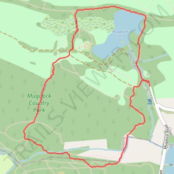
Trails in and around Mugdock Country Park
- Distance: 2.3 mi
- Elevation gain: 279 ft
- Maximum elevation: 535 ft
- Elevation loss: 285 ft
- Minimum elevation: 322 ft
- Moving time: 1 h 25 m
- Moving speed: 1.6 mph
- Maximum speed: 3.5 mph
- Total time: 1 h 31 m
- Global speed: 1.5 mph
Interactive trail map
Make a donation
Gear up for your next adventure:
As an Amazon Associate, this site earns from qualifying purchases at no extra cost to you.
Trail profile
- Distance: 2.3 mi
- Elevation gain: 279 ft
- Maximum elevation: 535 ft
- Elevation loss: 285 ft
- Minimum elevation: 322 ft
- Moving time: 1 h 25 m
- Moving speed: 1.6 mph
- Maximum speed: 3.5 mph
- Total time: 1 h 31 m
- Global speed: 1.5 mph
Make a donation
Gear up for your next adventure:
As an Amazon Associate, this site earns from qualifying purchases at no extra cost to you.
About this trail
Name: Trails in and around Mugdock Country Park trail, distance, elevation, map, profile, GPS track
End: Mugdock, Stirling, Scotland, G62 8BF, United Kingdom (55.96304 -4.31698)
Coordinates: 55.95810 -4.33075 55.96791 -4.31698
Make a donation
Gear up for your next adventure:
As an Amazon Associate, this site earns from qualifying purchases at no extra cost to you.
Other hiking, mountain biking, running and outdoor activity trails
Click on a trail to view its statistics, map and profile.
Loop Walk at Mugdock Country Park
United Kingdom > Scotland > Stirling > Mugdock
Distance: 1.6 mi • Elevation gain: 115 ft • Maximum elevation: 564 ft
West Highland Way between Milngavie and Craigallian Loch
United Kingdom > Scotland > East Dunbartonshire > Milngavie
Distance: 4.6 mi • Elevation gain: 272 ft • Maximum elevation: 384 ft
Loop Trail in and around Mugdock Country Park
United Kingdom > Scotland > East Dunbartonshire > Milngavie
Distance: 2.4 mi • Elevation gain: 299 ft • Maximum elevation: 535 ft
Make a donation
Gear up for your next adventure:
As an Amazon Associate, this site earns from qualifying purchases at no extra cost to you.
West Highland Way: Milngavie to Mugdock Park
United Kingdom > Scotland > East Dunbartonshire > Glasgow
Distance: 4.3 mi • Elevation gain: 236 ft • Maximum elevation: 377 ft
Loop walk in Mugdock County Park
United Kingdom > Scotland > Stirling > Mugdock
Distance: 2.9 mi • Elevation gain: 144 ft • Maximum elevation: 587 ft