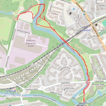
Walking trails along River Kelvin to Kelvin Aqueduct
- Distance: 1.6 mi
- Elevation gain: 98 ft
- Maximum elevation: 131 ft
- Elevation loss: 98 ft
- Minimum elevation: 85 ft
- Moving time: 49 m 18 s
- Moving speed: 1.9 mph
- Maximum speed: 6.0 mph
- Total time: 59 m 16 s
- Global speed: 1.6 mph
Interactive trail map
Trail profile
- Distance: 1.6 mi
- Elevation gain: 98 ft
- Maximum elevation: 131 ft
- Elevation loss: 98 ft
- Minimum elevation: 85 ft
- Moving time: 49 m 18 s
- Moving speed: 1.9 mph
- Maximum speed: 6.0 mph
- Total time: 59 m 16 s
- Global speed: 1.6 mph
About this trail
Name: Walking trails along River Kelvin to Kelvin Aqueduct trail, distance, elevation, map, profile, GPS track
Coordinates: 55.89256 -4.30936 55.89906 -4.30077
Other hiking, mountain biking, running and outdoor activity trails
Click on a trail to view its statistics, map and profile.
Johnstone, Scotland to Paisley via Glasgow
United Kingdom > Scotland > Renfrewshire > Johnstone
Bike
Distance: 40.5 mi • Elevation gain: 1,503 ft • Maximum elevation: 174 ft