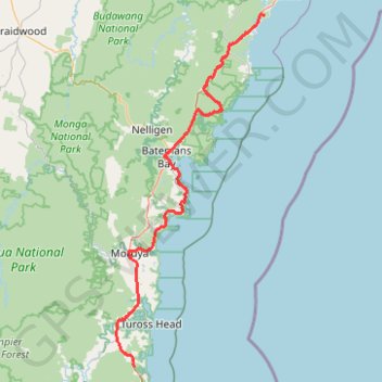
Dalmeny - Murramarang National Park - Meroo National Park - Dolphin Point (Ulladulla)
#Bike #Murramarang #Meroo
- Distance: 80.2 mi
- Elevation gain: 6,339 ft
- Maximum elevation: 397 ft
- Elevation loss: 6,358 ft
- Minimum elevation: -3 ft
Interactive trail map
Trail profile
- Distance: 80.2 mi
- Elevation gain: 6,339 ft
- Maximum elevation: 397 ft
- Elevation loss: 6,358 ft
- Minimum elevation: -3 ft
About this trail
Name: Dalmeny - Murramarang National Park - Meroo National Park - Dolphin Point (Ulladulla) trail, distance, elevation, map, profile, GPS track
Coordinates: -36.15164 150.04737 -35.40451 150.43685
Other hiking, mountain biking, running and outdoor activity trails
Click on a trail to view its statistics, map and profile.
Tura Beach - Bournda National Park - Mimosa Rocks National Park - Dalmeny
Australia > New South Wales > Tura Beach
Distance: 71.6 mi • Elevation gain: 6,624 ft • Maximum elevation: 492 ft
Murramarang South Coast Walk between Pretty Beach and Depot Beach
Distance: 7.3 mi • Elevation gain: 1,001 ft • Maximum elevation: 144 ft
Ulladulla - Minnamurra
Australia > New South Wales > Burrill Lake
#Bike
Distance: 79.4 mi • Elevation gain: 5,338 ft • Maximum elevation: 469 ft