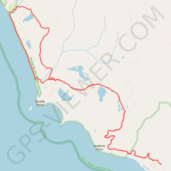
Alamere Falls Loop via Coast Trail
Interactive trail map
Trail profile
- Distance: 11.0 mi
- Elevation gain: 1,962 ft
- Maximum elevation: 610 ft
- Elevation loss: 1,962 ft
- Minimum elevation: 7 ft
About this trail
Name: Alamere Falls Loop via Coast Trail trail, distance, elevation, map, profile, GPS track
Start: Coast Trail, Marin County, California, United States (37.93410 -122.74650)
End: Coast Trail, Marin County, California, United States (37.93410 -122.74650)
Coordinates: 37.93410 -122.79125 37.97086 -122.74650
Topography: Marin County topographic map, elevation, terrain
Other hiking, mountain biking, running and outdoor activity trails
Click on a trail to view its statistics, map and profile.
Alamere Falls via Coast Trail in Point Reyes National Seashore
United States > California > Marin County
The hike to Alamere Falls via the Coast Trail in Point Reyes National Seashore offers a diverse array of landscapes, including coastal bluffs, serene lakes, and lush forests. Along the way, hikers can enjoy panoramic ocean vistas, pass by tranquil bodies of water such as Bass Lake and Pelican Lake, and…
Distance: 8.2 mi • Elevation gain: 1,558 ft • Maximum elevation: 610 ft
Alamere Falls via Coast Trail in Phillip Burton Wilderness Area
United States > California > Marin County
The Alamere Falls hike along the Coast Trail in the Point Reyes National Seashore is a enchanting journey that offers a variety of landscapes, from coastal views to serene lakes. Hikers are treated to a mix of coastal cliffs, rolling hills, and lush forests, with the opportunity to see two tranquil lakes along…
Distance: 4.1 mi • Elevation gain: 705 ft • Maximum elevation: 610 ft
Point Reyes Loop
United States > California > Marin County > Mill Valley
Distance: 62.3 mi • Elevation gain: 6,234 ft • Maximum elevation: 774 ft