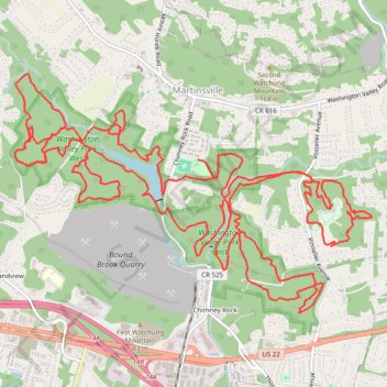
Washington Valley Park East and West Loop from Chimney Rock Park
- Distance: 19.7 mi
- Elevation gain: 2,037 ft
- Maximum elevation: 417 ft
- Elevation loss: 2,037 ft
- Minimum elevation: 157 ft
- Moving time: 3 h 41 m
- Moving speed: 5.3 mph
- Maximum speed: 14.7 mph
- Total time: 4 h 16 s
- Global speed: 4.9 mph
Interactive trail map
Trail profile
- Distance: 19.7 mi
- Elevation gain: 2,037 ft
- Maximum elevation: 417 ft
- Elevation loss: 2,037 ft
- Minimum elevation: 157 ft
- Moving time: 3 h 41 m
- Moving speed: 5.3 mph
- Maximum speed: 14.7 mph
- Total time: 4 h 16 s
- Global speed: 4.9 mph
About this trail
Name: Washington Valley Park East and West Loop from Chimney Rock Park trail, distance, elevation, map, profile, GPS track
Coordinates: 40.57947 -74.58249 40.60286 -74.53661
Topography: Somerset County topographic map, elevation, terrain