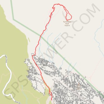
Turtlehead Peak Trail in Red Rock Canyon National Conservation Area
Turtlehead Peak Trail offers a fantastic blend of natural beauty and a bit of a workout. The hike takes you past ancient petroglyphs and up to a ridge with amazing views of Las Vegas and the stunning sandstone formations around you. While the trail can be rocky and steep in sections, the sense of accomplishment at the summit and the panoramic vistas make it all worthwhile. #Hiking #Mountain #Nature
- Distance: 4.7 mi
- Elevation gain: 2,008 ft
- Maximum elevation: 6,227 ft
- Elevation loss: 2,011 ft
- Minimum elevation: 4,321 ft
- Moving time: 2 h 36 m
- Moving speed: 1.8 mph
- Maximum speed: 3.4 mph
- Total time: 3 h 14 m
- Global speed: 1.5 mph
Interactive trail map
Trail profile
- Distance: 4.7 mi
- Elevation gain: 2,008 ft
- Maximum elevation: 6,227 ft
- Elevation loss: 2,011 ft
- Minimum elevation: 4,321 ft
- Moving time: 2 h 36 m
- Moving speed: 1.8 mph
- Maximum speed: 3.4 mph
- Total time: 3 h 14 m
- Global speed: 1.5 mph
About this trail
Name: Turtlehead Peak Trail in Red Rock Canyon National Conservation Area trail, distance, elevation, map, profile, GPS track
End: Trail maps, Calico Tanks Trail, Clark County, Nevada, United States (36.16244 -115.45037)
Coordinates: 36.16244 -115.45556 36.18382 -115.44470
Topography: Clark County topographic map, elevation, terrain
Other hiking, mountain biking, running and outdoor activity trails
Click on a trail to view its statistics, map and profile.
Calico Tanks Trail in Red Rock Canyon National Conservation Area
United States > Nevada > Clark County
The Calico Tanks Trail is a fantastic way to immerse yourself in the beauty of nature while enjoying some stunning views of the Las Vegas skyline. The trail is well-marked and provides a great workout, making it easy to explore the unique sandstone formations along the way. Starting early is a smart choice, as…
Distance: 2.5 mi • Elevation gain: 469 ft • Maximum elevation: 4,751 ft