Calico Tanks Trail in Red Rock Canyon National Conservation Area
The Calico Tanks Trail is a fantastic way to immerse yourself in the beauty of nature while enjoying some stunning views of the Las Vegas skyline. The trail is well-marked and provides a great workout, making it easy to explore the unique sandstone formations along the way. Starting early is a smart choice, as it allows you to savor the scenery without the heat of the day creeping in. #Hiking #Desert #Rock #Nature
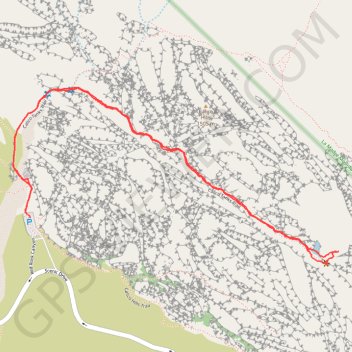
- Distance: 2.5 mi
- Elevation gain: 469 ft
- Maximum elevation: 4,751 ft
- Elevation loss: 469 ft
- Minimum elevation: 4,321 ft
- Moving time: 1 h 13 m
- Moving speed: 2.0 mph
- Maximum speed: 3.5 mph
- Total time: 1 h 26 m
- Global speed: 1.7 mph
Interactive trail map
Trail profile
- Distance: 2.5 mi
- Elevation gain: 469 ft
- Maximum elevation: 4,751 ft
- Elevation loss: 469 ft
- Minimum elevation: 4,321 ft
- Moving time: 1 h 13 m
- Moving speed: 2.0 mph
- Maximum speed: 3.5 mph
- Total time: 1 h 26 m
- Global speed: 1.7 mph
About this trail
Name: Calico Tanks Trail in Red Rock Canyon National Conservation Area trail, distance, elevation, map, profile, GPS track
Start: Sandstone Quarry Parking, Red Rock Canyon, Clark County, Nevada, United States (36.16243 -115.45036)
Coordinates: 36.16068 -115.45088 36.16669 -115.43719
Topography: Clark County topographic map, elevation, terrain
Other hiking, mountain biking, running and outdoor activity trails
Click on a trail to view its statistics, map and profile.
Turtlehead Peak Trail in Red Rock Canyon National Conservation Area
United States > Nevada > Clark County
Turtlehead Peak Trail offers a fantastic blend of natural beauty and a bit of a workout. The hike takes you past ancient petroglyphs and up to a ridge with amazing views of Las Vegas and the stunning sandstone formations around you. While the trail can be rocky and steep in sections, the sense of…
Distance: 4.7 mi • Elevation gain: 2,008 ft • Maximum elevation: 6,227 ft