Make a donation
Gear up for your next adventure:
As an Amazon Associate, this site earns from qualifying purchases at no extra cost to you.
7 Mile Diggings - Nanango
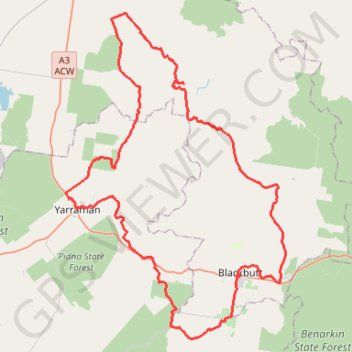
Interactive trail map
Make a donation
Gear up for your next adventure:
As an Amazon Associate, this site earns from qualifying purchases at no extra cost to you.
Trail profile
- Distance: 51.4 mi
- Elevation gain: 3,986 ft
- Maximum elevation: 1,847 ft
- Elevation loss: 3,990 ft
- Minimum elevation: 669 ft
Make a donation
Gear up for your next adventure:
As an Amazon Associate, this site earns from qualifying purchases at no extra cost to you.
About this trail
Name: 7 Mile Diggings - Nanango trail, distance, elevation, map, profile, GPS track
Coordinates: -26.92731 151.97275 -26.70979 152.13732
Make a donation
Gear up for your next adventure:
As an Amazon Associate, this site earns from qualifying purchases at no extra cost to you.
Other hiking, mountain biking, running and outdoor activity trails
Click on a trail to view its statistics, map and profile.
Goodger to Nanango
Goodger, Kunioon, Brooklands, South Nanango, Nanango, Barker Creek Flat, Queensland
Distance: 32.3 mi • Elevation gain: 1,916 ft • Maximum elevation: 1,657 ft
Make a donation
Gear up for your next adventure:
As an Amazon Associate, this site earns from qualifying purchases at no extra cost to you.