Fridaythorpe Loop Trail Running
- Distance: 9.7 mi
- Elevation gain: 883 ft
- Maximum elevation: 709 ft
- Elevation loss: 883 ft
- Minimum elevation: 289 ft
- Moving time: 2 h 11 m
- Moving speed: 4.4 mph
- Maximum speed: 7.4 mph
- Total time: 2 h 16 m
- Global speed: 4.3 mph
Interactive trail map
Trail profile
- Distance: 9.7 mi
- Elevation gain: 883 ft
- Maximum elevation: 709 ft
- Elevation loss: 883 ft
- Minimum elevation: 289 ft
- Moving time: 2 h 11 m
- Moving speed: 4.4 mph
- Maximum speed: 7.4 mph
- Total time: 2 h 16 m
- Global speed: 4.3 mph
About this trail
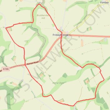
Name: Fridaythorpe Loop Trail Running trail, distance, elevation, map, profile, GPS track
Coordinates: 53.98996 -0.70688 54.03317 -0.63582
Other hiking, mountain biking, running and outdoor activity trails
Click on a trail to view its statistics, map and profile.
East Riding of Yorkshire Trail Running
United Kingdom > England > East Riding of Yorkshire > Millington > Givendale
Loop run / hike from Givendale via Whitekeld Beck, Deep Dale, Millington Dale, Nettle Dale, Frendal Dale, Fenstone Quarries, Keasey Dale, Carden Dale, Coldwold Farm, Warren Farm, Wan Dale, Millington and Little Givendale Farm. #Running #Hiking #Loop #Coutryside #Nature #River #Forest
Distance: 18.7 mi • Elevation gain: 2,415 ft • Maximum elevation: 784 ft
Hike from Pocklington to Fridaythorpe
United Kingdom > England > East Riding of Yorkshire > York
Distance: 10.9 mi • Elevation gain: 1,545 ft • Maximum elevation: 676 ft
East Riding of Yorkshire Trail Running
United Kingdom > England > East Riding of Yorkshire
Distance: 20.8 mi • Elevation gain: 1,657 ft • Maximum elevation: 771 ft
Fridaythorpe loop
United Kingdom > England > East Riding of Yorkshire > Fridaythorpe
East Riding of Yorkshire Hiking
Distance: 7.5 mi • Elevation gain: 663 ft • Maximum elevation: 709 ft
Fridaythorpe south loop
United Kingdom > England > East Riding of Yorkshire > Fridaythorpe
Distance: 7.6 mi • Elevation gain: 679 ft • Maximum elevation: 709 ft
Thixendale Loop
United Kingdom > England > North Yorkshire > Thixendale
Distance: 9.5 mi • Elevation gain: 1,299 ft • Maximum elevation: 692 ft