Make a donation
Gear up for your next adventure:
As an Amazon Associate, this site earns from qualifying purchases at no extra cost to you.
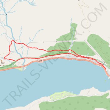
Loop Walk from St Fillans to Jerusalem in Glen Tarken
- Distance: 3.8 mi
- Elevation gain: 650 ft
- Maximum elevation: 774 ft
- Elevation loss: 663 ft
- Minimum elevation: 354 ft
- Moving time: 1 h 34 m
- Moving speed: 2.4 mph
- Maximum speed: 4.5 mph
- Total time: 1 h 58 m
- Global speed: 1.9 mph
Interactive trail map
Make a donation
Gear up for your next adventure:
As an Amazon Associate, this site earns from qualifying purchases at no extra cost to you.
Trail profile
- Distance: 3.8 mi
- Elevation gain: 650 ft
- Maximum elevation: 774 ft
- Elevation loss: 663 ft
- Minimum elevation: 354 ft
- Moving time: 1 h 34 m
- Moving speed: 2.4 mph
- Maximum speed: 4.5 mph
- Total time: 1 h 58 m
- Global speed: 1.9 mph
Make a donation
Gear up for your next adventure:
As an Amazon Associate, this site earns from qualifying purchases at no extra cost to you.
About this trail
Name: Loop Walk from St Fillans to Jerusalem in Glen Tarken trail, distance, elevation, map, profile, GPS track
Start: Foxknowe, St Fillans, Perth and Kinross, Scotland, PH6 2NG, United Kingdom (56.39488 -4.12286)
End: St Fillans, Perth and Kinross, Scotland, PH6 2NF, United Kingdom (56.39447 -4.12256)
Coordinates: 56.39447 -4.16361 56.40110 -4.12256
Make a donation
Gear up for your next adventure:
As an Amazon Associate, this site earns from qualifying purchases at no extra cost to you.
Other hiking, mountain biking, running and outdoor activity trails
Click on a trail to view its statistics, map and profile.