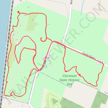
Clermont State Historic Site
- Distance: 5.7 mi
- Elevation gain: 410 ft
- Maximum elevation: 210 ft
- Elevation loss: 413 ft
- Minimum elevation: 33 ft
- Moving time: 1 h 34 m
- Moving speed: 3.6 mph
- Maximum speed: 19.8 mph
- Total time: 2 h 38 m
- Global speed: 2.2 mph
Interactive trail map
Trail profile
- Distance: 5.7 mi
- Elevation gain: 410 ft
- Maximum elevation: 210 ft
- Elevation loss: 413 ft
- Minimum elevation: 33 ft
- Moving time: 1 h 34 m
- Moving speed: 3.6 mph
- Maximum speed: 19.8 mph
- Total time: 2 h 38 m
- Global speed: 2.2 mph
About this trail
Name: Clermont State Historic Site trail, distance, elevation, map, profile, GPS track
Coordinates: 42.07740 -73.92091 42.08914 -73.90239
Topography: Columbia County topographic map, elevation, terrain
Other hiking, mountain biking, running and outdoor activity trails
Click on a trail to view its statistics, map and profile.