Southeast French Park Loop Walk
- Distance: 2.6 mi
- Elevation gain: 282 ft
- Maximum elevation: 853 ft
- Elevation loss: 276 ft
- Minimum elevation: 676 ft
- Moving time: 1 h 25 m
- Moving speed: 1.8 mph
- Maximum speed: 3.4 mph
- Total time: 2 h 52 m
- Global speed: 0.9 mph
Interactive trail map
Trail profile
- Distance: 2.6 mi
- Elevation gain: 282 ft
- Maximum elevation: 853 ft
- Elevation loss: 276 ft
- Minimum elevation: 676 ft
- Moving time: 1 h 25 m
- Moving speed: 1.8 mph
- Maximum speed: 3.4 mph
- Total time: 2 h 52 m
- Global speed: 0.9 mph
About this trail
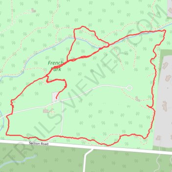
Name: Southeast French Park Loop Walk trail, distance, elevation, map, profile, GPS track
Coordinates: 39.19537 -84.42786 39.20095 -84.41823
Topography: Hamilton County topographic map, elevation, terrain