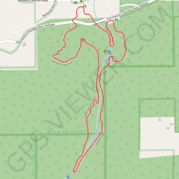
Latourell Falls Loop
Interactive trail map
Trail profile
- Distance: 2.1 mi
- Elevation gain: 876 ft
- Maximum elevation: 745 ft
- Elevation loss: 876 ft
- Minimum elevation: 131 ft
About this trail
Name: Latourell Falls Loop trail, distance, elevation, map, profile, GPS track
Coordinates: 45.53070 -122.22227 45.53947 -122.21674
Topography: Multnomah County topographic map, elevation, terrain
Other hiking, mountain biking, running and outdoor activity trails
Click on a trail to view its statistics, map and profile.
Latourell Falls Loop Trail in Guy W. Talbot State Park
United States > Oregon > Multnomah County > Latourell
The Latourell Falls Loop Trail offers a picturesque and relatively moderate hike through the lush forests of the Columbia River Gorge. Starting near the impressive Lower Latourell Falls, the trail quickly immerses you in a verdant landscape filled with moss-covered trees and ferns. As you ascend, you'll…
Distance: 2.2 mi • Elevation gain: 932 ft • Maximum elevation: 787 ft
Expedition to Sedum Ridge
United States > Oregon > Multnomah County > Portland
Distance: 133.4 mi • Elevation gain: 16,709 ft • Maximum elevation: 3,835 ft