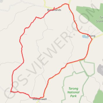
Brooklands to Maidenwell
Brooklands, Maidenwell, Tarong, Queensland
- Distance: 24.0 mi
- Elevation gain: 1,512 ft
- Maximum elevation: 1,785 ft
- Elevation loss: 1,512 ft
- Minimum elevation: 1,224 ft
Interactive trail map
Trail profile
- Distance: 24.0 mi
- Elevation gain: 1,512 ft
- Maximum elevation: 1,785 ft
- Elevation loss: 1,512 ft
- Minimum elevation: 1,224 ft
About this trail
Name: Brooklands to Maidenwell trail, distance, elevation, map, profile, GPS track
Coordinates: -26.84727 151.76141 -26.73564 151.86866
Other hiking, mountain biking, running and outdoor activity trails
Click on a trail to view its statistics, map and profile.
Goodger to Ellesmere and Archookoora State Forest
Goodger, Brooklands, Ellesmere, Haly Creek, Archookoora, Queensland
Distance: 29.7 mi • Elevation gain: 2,041 ft • Maximum elevation: 1,808 ft
Goodger to Ellesmere
Goodger, Brooklands, Ellesmere, Haly Creek, Archookoora, Queensland
Distance: 26.6 mi • Elevation gain: 1,230 ft • Maximum elevation: 2,018 ft
Oaky Creek Back Road
Distance: 15.3 mi • Elevation gain: 971 ft • Maximum elevation: 1,909 ft