Make a donation
Gear up for your next adventure:
As an Amazon Associate, this site earns from qualifying purchases at no extra cost to you.
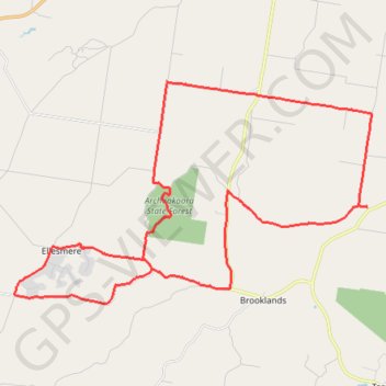
Goodger to Ellesmere and Archookoora State Forest
Goodger, Brooklands, Ellesmere, Haly Creek, Archookoora, Queensland
- Distance: 29.7 mi
- Elevation gain: 2,041 ft
- Maximum elevation: 1,808 ft
- Elevation loss: 2,041 ft
- Minimum elevation: 1,211 ft
Interactive trail map
Make a donation
Gear up for your next adventure:
As an Amazon Associate, this site earns from qualifying purchases at no extra cost to you.
Trail profile
- Distance: 29.7 mi
- Elevation gain: 2,041 ft
- Maximum elevation: 1,808 ft
- Elevation loss: 2,041 ft
- Minimum elevation: 1,211 ft
Make a donation
Gear up for your next adventure:
As an Amazon Associate, this site earns from qualifying purchases at no extra cost to you.
About this trail
Name: Goodger to Ellesmere and Archookoora State Forest trail, distance, elevation, map, profile, GPS track
Start: Neale Road, Goodger, South Burnett Regional, Queensland, Australia (-26.66605 151.78086)
End: Neale Road, Goodger, South Burnett Regional, Queensland, Australia (-26.66606 151.78084)
Coordinates: -26.74392 151.72092 -26.66605 151.86135
Make a donation
Gear up for your next adventure:
As an Amazon Associate, this site earns from qualifying purchases at no extra cost to you.
Other hiking, mountain biking, running and outdoor activity trails
Click on a trail to view its statistics, map and profile.
Ushers Hill and Archookoora State Forest loop
Distance: 32.7 mi • Elevation gain: 2,149 ft • Maximum elevation: 1,847 ft
Goodger to Nanango
Goodger, Kunioon, Brooklands, South Nanango, Nanango, Barker Creek Flat, Queensland
Distance: 32.3 mi • Elevation gain: 1,916 ft • Maximum elevation: 1,657 ft
Goodger to Ellesmere
Goodger, Brooklands, Ellesmere, Haly Creek, Archookoora, Queensland
Distance: 26.6 mi • Elevation gain: 1,230 ft • Maximum elevation: 2,018 ft
Brooklands to Maidenwell
Australia > Queensland > Brooklands
Brooklands, Maidenwell, Tarong, Queensland
Distance: 24.0 mi • Elevation gain: 1,512 ft • Maximum elevation: 1,785 ft
Make a donation
Gear up for your next adventure:
As an Amazon Associate, this site earns from qualifying purchases at no extra cost to you.
Inverlaw to Kumbia
Inverlaw, Benair, Kumbia, Queensland
Distance: 25.3 mi • Elevation gain: 1,102 ft • Maximum elevation: 1,762 ft
Kumbia to Benair loop
Australia > Queensland > Kumbia
Distance: 18.9 mi • Elevation gain: 896 ft • Maximum elevation: 1,795 ft
Oaky Creek Back Road
Distance: 15.3 mi • Elevation gain: 971 ft • Maximum elevation: 1,909 ft