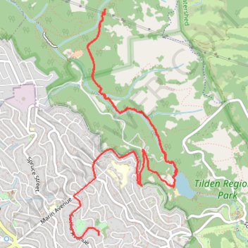
Lake Anza - Tilden Regional Park
- Distance: 5.9 mi
- Elevation gain: 912 ft
- Maximum elevation: 971 ft
- Elevation loss: 997 ft
- Minimum elevation: 574 ft
- Moving time: 1 h 49 m
- Moving speed: 3.2 mph
- Maximum speed: 29.2 mph
- Total time: 2 h 4 m
- Global speed: 2.8 mph
Interactive trail map
Trail profile
- Distance: 5.9 mi
- Elevation gain: 912 ft
- Maximum elevation: 971 ft
- Elevation loss: 997 ft
- Minimum elevation: 574 ft
- Moving time: 1 h 49 m
- Moving speed: 3.2 mph
- Maximum speed: 29.2 mph
- Total time: 2 h 4 m
- Global speed: 2.8 mph
About this trail
Name: Lake Anza - Tilden Regional Park trail, distance, elevation, map, profile, GPS track
Start: Lake Anza Trail, Contra Costa County, California, 94708, United States (37.89610 -122.25160)
Coordinates: 37.89076 -122.26505 37.91441 -122.25116
Topography: Contra Costa County topographic map, elevation, terrain
Other hiking, mountain biking, running and outdoor activity trails
Click on a trail to view its statistics, map and profile.
Meadows Canyon Trail - Wildcat Creek Trail
United States > California > Contra Costa County
Morning Run
Distance: 2.8 mi • Elevation gain: 581 ft • Maximum elevation: 1,017 ft