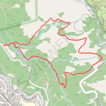
Meadows Canyon Trail - Wildcat Creek Trail
Morning Run
- Distance: 2.8 mi
- Elevation gain: 581 ft
- Maximum elevation: 1,017 ft
- Elevation loss: 581 ft
- Minimum elevation: 574 ft
- Moving time: 37 m 4 s
- Moving speed: 4.6 mph
- Maximum speed: 8.7 mph
- Total time: 37 m 49 s
- Global speed: 4.5 mph
Interactive trail map
Trail profile
- Distance: 2.8 mi
- Elevation gain: 581 ft
- Maximum elevation: 1,017 ft
- Elevation loss: 581 ft
- Minimum elevation: 574 ft
- Moving time: 37 m 4 s
- Moving speed: 4.6 mph
- Maximum speed: 8.7 mph
- Total time: 37 m 49 s
- Global speed: 4.5 mph
About this trail
Name: Meadows Canyon Trail - Wildcat Creek Trail trail, distance, elevation, map, profile, GPS track
Start: Wildcat Gorge Trail, Contra Costa County, California, 94708, United States (37.90566 -122.26106)
Coordinates: 37.90014 -122.26234 37.90887 -122.24685
Topography: Contra Costa County topographic map, elevation, terrain
Other hiking, mountain biking, running and outdoor activity trails
Click on a trail to view its statistics, map and profile.
Big Springs Trail and Seaview Trail Loop in Tilden Regional Park
United States > California > Contra Costa County
The Big Springs Trail and Seaview Trail Loop in Tilden Regional Park offers a delightful hiking experience, combining shaded woodlands with open meadows. Hikers can enjoy panoramic vistas of the San Francisco skyline, the bay, and the San Pablo Reservoir. The route's moderate elevation changes and diverse…
Distance: 4.3 mi • Elevation gain: 968 ft • Maximum elevation: 1,660 ft
Lake Anza - Tilden Regional Park
United States > California > Contra Costa County
Distance: 5.9 mi • Elevation gain: 912 ft • Maximum elevation: 971 ft