Thank you for supporting this site ❤️
Make a donation
Make a donation
Gear up for your next adventure:
As an Amazon Associate, this site earns from qualifying purchases at no extra cost to you.
Koegel Park loop
- Distance: 2.4 mi
- Elevation gain: 266 ft
- Maximum elevation: 666 ft
- Elevation loss: 282 ft
- Minimum elevation: 554 ft
- Moving time: 49 m 33 s
- Moving speed: 2.9 mph
- Maximum speed: 5.2 mph
- Total time: 53 m 28 s
- Global speed: 2.7 mph
Interactive trail map
Thank you for supporting this site ❤️
Make a donation
Make a donation
Gear up for your next adventure:
As an Amazon Associate, this site earns from qualifying purchases at no extra cost to you.
Trail profile
- Distance: 2.4 mi
- Elevation gain: 266 ft
- Maximum elevation: 666 ft
- Elevation loss: 282 ft
- Minimum elevation: 554 ft
- Moving time: 49 m 33 s
- Moving speed: 2.9 mph
- Maximum speed: 5.2 mph
- Total time: 53 m 28 s
- Global speed: 2.7 mph
Thank you for supporting this site ❤️
Make a donation
Make a donation
Gear up for your next adventure:
As an Amazon Associate, this site earns from qualifying purchases at no extra cost to you.
About this trail
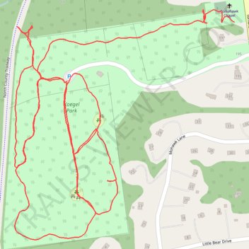
Name: Koegel Park loop trail, distance, elevation, map, profile, GPS track
Coordinates: 41.32560 -73.75762 41.33085 -73.75095
Topography: Westchester County topographic map, elevation, terrain
Thank you for supporting this site ❤️
Make a donation
Make a donation
Gear up for your next adventure:
As an Amazon Associate, this site earns from qualifying purchases at no extra cost to you.
Other hiking, mountain biking, running and outdoor activity trails
Click on a trail to view its statistics, map and profile.