Thank you for supporting this site ❤️
Make a donation
Make a donation
Gear up for your next adventure:
As an Amazon Associate, this site earns from qualifying purchases at no extra cost to you.
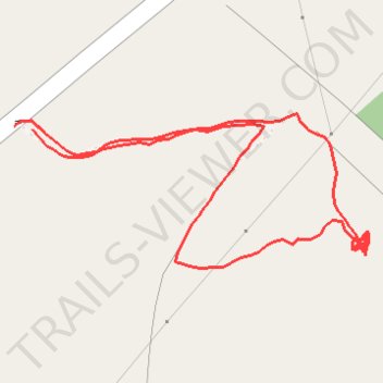
Cave of the Killer Rabbit of Caerbannog
- Distance: 0.5 mi
- Elevation gain: 174 ft
- Maximum elevation: 784 ft
- Elevation loss: 180 ft
- Minimum elevation: 600 ft
- Moving time: 16 m 28 s
- Moving speed: 1.8 mph
- Maximum speed: 4.8 mph
- Total time: 28 m 3 s
- Global speed: 1.1 mph
Interactive trail map
Thank you for supporting this site ❤️
Make a donation
Make a donation
Gear up for your next adventure:
As an Amazon Associate, this site earns from qualifying purchases at no extra cost to you.
Trail profile
- Distance: 0.5 mi
- Elevation gain: 174 ft
- Maximum elevation: 784 ft
- Elevation loss: 180 ft
- Minimum elevation: 600 ft
- Moving time: 16 m 28 s
- Moving speed: 1.8 mph
- Maximum speed: 4.8 mph
- Total time: 28 m 3 s
- Global speed: 1.1 mph
Thank you for supporting this site ❤️
Make a donation
Make a donation
Gear up for your next adventure:
As an Amazon Associate, this site earns from qualifying purchases at no extra cost to you.
About this trail
Name: Cave of the Killer Rabbit of Caerbannog trail, distance, elevation, map, profile, GPS track
Start: Ardtalnaig, Perth and Kinross, Scotland, PH15 2HX, United Kingdom (56.51461 -4.13088)
End: Ardtalnaig, Perth and Kinross, Scotland, PH15 2HX, United Kingdom (56.51463 -4.13107)
Coordinates: 56.51384 -4.13107 56.51470 -4.12751
Thank you for supporting this site ❤️
Make a donation
Make a donation
Gear up for your next adventure:
As an Amazon Associate, this site earns from qualifying purchases at no extra cost to you.
Other hiking, mountain biking, running and outdoor activity trails
Click on a trail to view its statistics, map and profile.