Make a donation
Gear up for your next adventure:
As an Amazon Associate, this site earns from qualifying purchases at no extra cost to you.
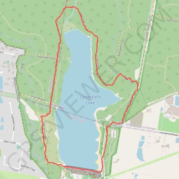
Lysterfield Lake Loop
Lysterfield Park. #Hiking #Loop #Lysterfield
- Distance: 3.8 mi
- Elevation gain: 302 ft
- Maximum elevation: 344 ft
- Elevation loss: 302 ft
- Minimum elevation: 203 ft
- Moving time: 1 h 2 m
- Moving speed: 3.7 mph
- Maximum speed: 12.6 mph
- Total time: 1 h 2 m
- Global speed: 3.7 mph
Interactive trail map
Make a donation
Gear up for your next adventure:
As an Amazon Associate, this site earns from qualifying purchases at no extra cost to you.
Trail profile
- Distance: 3.8 mi
- Elevation gain: 302 ft
- Maximum elevation: 344 ft
- Elevation loss: 302 ft
- Minimum elevation: 203 ft
- Moving time: 1 h 2 m
- Moving speed: 3.7 mph
- Maximum speed: 12.6 mph
- Total time: 1 h 2 m
- Global speed: 3.7 mph
Make a donation
Gear up for your next adventure:
As an Amazon Associate, this site earns from qualifying purchases at no extra cost to you.
About this trail
Name: Lysterfield Lake Loop trail, distance, elevation, map, profile, GPS track
Coordinates: -37.97125 145.29218 -37.95287 145.30581
Make a donation
Gear up for your next adventure:
As an Amazon Associate, this site earns from qualifying purchases at no extra cost to you.
Other hiking, mountain biking, running and outdoor activity trails
Click on a trail to view its statistics, map and profile.
Lysterfield Park MTB Loop
Australia > Victoria > Melbourne
#MTB #Loop #Lysterfield
Distance: 10.3 mi • Elevation gain: 1,247 ft • Maximum elevation: 682 ft
Lysterfield Lake Loop
Australia > Victoria > Melbourne
Lysterfield Park. #Hiking #Loop #Lysterfield
Distance: 3.6 mi • Elevation gain: 272 ft • Maximum elevation: 331 ft
Upwey - Lysterfield Lake
Australia > Victoria > Melbourne
Distance: 15.2 mi • Elevation gain: 2,411 ft • Maximum elevation: 692 ft
Lysterfield Park
Australia > Victoria > Melbourne
Distance: 4.2 mi • Elevation gain: 686 ft • Maximum elevation: 659 ft
Make a donation
Gear up for your next adventure:
As an Amazon Associate, this site earns from qualifying purchases at no extra cost to you.