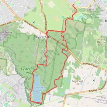
Upwey - Lysterfield Lake
- Distance: 15.2 mi
- Elevation gain: 2,411 ft
- Maximum elevation: 692 ft
- Elevation loss: 2,503 ft
- Minimum elevation: 203 ft
Interactive trail map
Trail profile
- Distance: 15.2 mi
- Elevation gain: 2,411 ft
- Maximum elevation: 692 ft
- Elevation loss: 2,503 ft
- Minimum elevation: 203 ft
About this trail
Name: Upwey - Lysterfield Lake trail, distance, elevation, map, profile, GPS track
Coordinates: -37.97120 145.29253 -37.91682 145.32520
Other hiking, mountain biking, running and outdoor activity trails
Click on a trail to view its statistics, map and profile.
Lysterfield Park MTB Loop
Australia > Victoria > Melbourne
#MTB #Loop #Lysterfield
Distance: 10.3 mi • Elevation gain: 1,247 ft • Maximum elevation: 682 ft
Lysterfield Lake Loop
Australia > Victoria > Melbourne
Lysterfield Park. #Hiking #Loop #Lysterfield
Distance: 3.6 mi • Elevation gain: 272 ft • Maximum elevation: 331 ft
Lysterfield Lake Loop
Australia > Victoria > Melbourne
Lysterfield Park. #Hiking #Loop #Lysterfield
Distance: 3.8 mi • Elevation gain: 302 ft • Maximum elevation: 344 ft
Lysterfield, Baluk William, Mount Morton, Birdsland
Australia > Victoria > Melbourne
Distance: 8.0 mi • Elevation gain: 1,198 ft • Maximum elevation: 876 ft
Churchill National Park, Lysterfield Park
Australia > Victoria > Melbourne
Distance: 6.9 mi • Elevation gain: 1,270 ft • Maximum elevation: 735 ft
Lysterfield Park
Australia > Victoria > Melbourne
Distance: 4.2 mi • Elevation gain: 686 ft • Maximum elevation: 659 ft