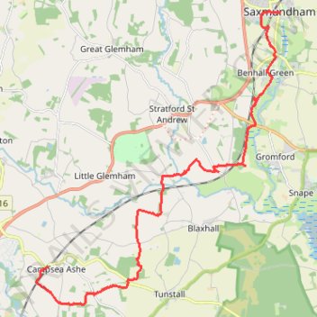
Walk to Saxmundham
- Distance: 11.1 mi
- Elevation gain: 315 ft
- Maximum elevation: 98 ft
- Elevation loss: 354 ft
- Minimum elevation: 7 ft
- Moving time: 3 h 26 m
- Moving speed: 3.2 mph
- Maximum speed: 4.9 mph
- Total time: 3 h 35 m
- Global speed: 3.1 mph
Interactive trail map
Trail profile
- Distance: 11.1 mi
- Elevation gain: 315 ft
- Maximum elevation: 98 ft
- Elevation loss: 354 ft
- Minimum elevation: 7 ft
- Moving time: 3 h 26 m
- Moving speed: 3.2 mph
- Maximum speed: 4.9 mph
- Total time: 3 h 35 m
- Global speed: 3.1 mph
About this trail
Name: Walk to Saxmundham trail, distance, elevation, map, profile, GPS track
Start: B1078, Campsea Ashe, East Suffolk, Suffolk, England, IP13 0QP, United Kingdom (52.15117 1.39825)
Coordinates: 52.14177 1.39378 52.21414 1.49198
Other hiking, mountain biking, running and outdoor activity trails
Click on a trail to view its statistics, map and profile.
Tunstall Forest and Rendlesham Forest Loop from Bawdsey Manor
United Kingdom > England > Suffolk > East Suffolk > Bawdsey
Distance: 40.5 mi • Elevation gain: 1,322 ft • Maximum elevation: 112 ft